Canyonlands
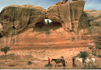
Horse trail group below one of the arches at Canyonlands National Park. Image courtesy National Park Service.
Associate Pages
-
Visitor Statistics
818,492 visitors
Canyonlands National Park
#90 Most Visited National Park Unit
Source: NPS, Rank among 398 National Park Units 2024.
Park Size
337,570 Acres Federal; 337,598 Acres Total
Park Fees
Vehicle (7 Day) - $30
Motorcycle (7 Day) - $25
Single (No Car) on Bike/Hike (7 Day) - $15
Southeast Utah Park Pass (Year Pass to Arches, Canyonlands, and Natural Bridges) - $50
Camping Fee Additional
Fees subject to change without notice.
Weather
Summer - The temperatures are hot in summer months with aveage temperatures in the high 90s to low 100s. The temperature is known to flunctuate here, sometimes 40 degrees in a couple hours. Be prepared. There's not a whole lot of summer precipitation, but it does snow in winter, not as much as in the surrounding mountains, but it does snow.
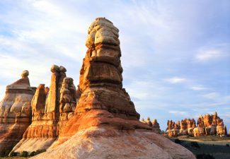
Photo above: Spires rising above the canyon floors at Canyonlands National Park. Right: Grass and water pools formed by the runoff into the Green and Colorado Rivers. Source: National Park Service.

Canyonlands National Park
Odd in a way as part of the double whammy national parks not far from the doorsteps of Moab, Utah, but Canyonlands, at nearly five times the size, is the poor sister, gathering less than 40% of the attendance of Arches National Park. But don't let that fool you into thinking there's nothing special about all that land west of the Moab. In two distinct areas, the Island of the Sky and Needles, you'll get to witness beauty with the panache reserved for few places on earth, camp under the stars, poke around the two visitors centers, and return refreshed to regular life anxious to return to the large sister who just does not get enough attention. Guess people are waiting for her to lose weight. Oh, no, microagression toward a national park. Forget we said that. Just visit her and judge for yourself.
Click here to Sponsor the page and how to reserve your ad.

Canyonlands Then
Hunter gatherers wandered these canyons eight thousand years ago, leaving traces of their past in Puebloan Granaries in the Roadside Ruin and rock art in Horseshoe Canyon. The Ute and Paiute people arrived near 800 A.D. and the Navajo five hundred years later. Yes, that's five hundred years. And all three cultures still live in the area today. European explorers came, staying for good after use of the Old Spanish Trail, but it wasn't until 1869 that an offical exploration of the area occurred with the Major John Wesley Powell Expedition.
An odd confluence of outcomes occurred in the 1950s when miners looking for uranium for the U.S. nuclear arms program began creating roads through the Canyonlands area to their mines. The area actually produced very little uranium, but did leave the remnants of those roads for tourists to slowly discover the area. Today those roads lead to backcountry adventure as well as overlook wonder and trails for the national park visitors that traverse the area. The park itself was created on September 12, 1964 by President Lyndon Johnson.
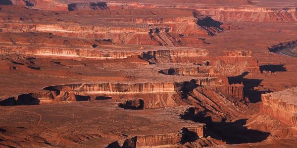
Photo above: Some of the historic petroglyphs within Canyonlands National Park. Photo courtesy National Park Service. Below: Green River meandering through the park from the from the Green River Overlook, Island in the Sky District. Photo courtesy Wikipedia Commons.
Canyonlands Now
One of the difference you'll note right away between Arches and Canyonlands is that there's more water here with the opportunity to white water raft through it. The Colorado River goes by Arches, but it meanders through Canyonlands, along with the Green River on the western side. Now, neither of these are close to the main Visitor Center areas and require backcountry visitation and access points outside the park, but they're there. At the main Visitor Centers in the Island in the Sky District or Needles District, you'll the opportunities for scenic overviews and hiking are almost endless, as is the sky.
The main road past the Island in the Sky Visitor Center will take you to Shafer Canyon Overlook, Mesa Arch, Holman Spring Canyon Overlook, Whale Rock, Upheaval Dome, Green River Overlook, Buck Canyon Overlook, Orange Cliffs Overlook, and Grand View Point. From the Needles Visitor Center, your car or foot caravan can take you to the Roadside Ruin, Wooden Shoe Arch Overlook, Squaw Flat, Pothole Point, and the Big Spring Canyon Overlook. Many of these overlooks site 1,000 feet above the canyon floor. Whew! That's a lot to see. Be careful not to get dizzy.
T-Shirts and Souvenirs

Canyonlands National Park T-Shirts and Souvenirs from the official merchandise of America's Best History. Great for your next western vacation or planning session.
Canyonlands
Things You Should Not Miss
1. Stop at the Island in the Sky Visitor Center and watch the orientation film, then head out on the auto tour. Remember, you'll be one thousand feet above the canyon floor and see magnificent spots for photos.
2. Take in one of the guided ranger tours during the March to October high season. There are two regular tours daily from Island in the Sky and a night program at the Squaw Flat Campground at Needles.
3. If you're adventurous, at least in a modest way, drive the upaved three mile Elephant Hill and gander at a long distant view of the Needles.
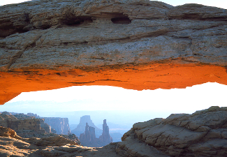
Photo above: Sunlight streaming into the underbelly of an arch at Canyonlands National Park. Source: National Park Service.

Freeborn, the Novel about the Wild West's most unlikely hero.
Visitor FAQ

What's There Now
Canyonlands National Park
Two Visitor Centers:
Island of the Sky Visitor Center - North section of the park. It has exhibits, a book store, and ranger orientation. It is open spring through fall, closing from December 31 to mid-March.
Needles Visitor Center - Southeast section of the park. It also has exhibits about the park, a book store, and rangers on duty. It is open early March to the end of November. Water is available here year round.
Maze Ranger Station - While the Maze section has limited access and no visitor center, there is a Ranger Station staffed year round to issue permits and give general information.
There are hundreds of miles of hiking trails in the park, segmented by the three districts, Island in the Sky, Needles, and the Maze. The Maze is only accessbile as a backcountry camping destination while the other two have easy to strenous hikes depending on your fitness and desirability.
Island in the Sky District
Trails under One Mile - Mesa Arch. This trail is considered Easy by the Park Service and is the only under one mile trail designed that way.
Trails over One Mile - Grand View (Easy), Murphy Point (Easy), Upheaval Dome (Moderate), Whale Rock (Moderate), Aztec Butte (Moderate), Neck Spring (Moderate). Strenous trails only for the experienced and hardy include Gooseberry Canyon (5.4 miles), Syncline Loop (8.3 miles), Murphy Loop (10.8 miles), Whilhite Canyon (12.2 miles), Taylor Canyon (20 miles), and Lathrop Canyon (21.6 miles).
Photo above: Above: Rafting down the Big Drop 1, Cataract Canyon along the Colorado River in Canyonlands National Park. Photo courtesy Wikipedia Commons/National Park Service.
Needles District
Trails under One Mile - Roadside Ruin, Pothole Point, and Cave Springs. These trails are listed as Easy/Moderate by the Park Service.
Trails over One Mile - Slickrock (Moderate). All others are listed as strenous, only suitable for the fit experience hiker; Big Spring to Squaw Canyon (7.5 miles), Squaw Canyon to Lost Canyon (8.7 miles), Confluence Overlook (10 miles), Peekaboo (10 miles), Chesler Park/Joint Trail (11 miles), Elephant Canyon/Druid Arch (11 miles), Lower Red Lake Canyon (18.8 miles), and Salt Creek Canyon (22.5 miles).
Directions to the Park
Canyonlands National Park is located thirty-two miles west of Moab, Utah. From Moab, take Route 191 north past the entrance station to Arches National Park, then west/south on Route 313 to the park. You will be entering at the North Entrance with the Island in the Sky Visitor Center just ahead. Access to the southern section of the Park, the Needles section, is through Route 211 West off Route 191. The Needles Visitor Center is thirty-five miles off Route 191.
Lodging and Camping
There is no hotel or motel lodging within Canyonlands National Park. There is one campsite in the Island in the Sky District of the park, Willow Flat with 12 sites, and one in the Needles section, Squaw Flat with 26 sites. There is no water at Willow Flat. Three other Group Campsites also exist in the Needles section, two at Squaw Flat and one at Wooden Shoe. Backcountry camping is also permitted in all three zones, including the Maze, with a permit for up to fourteen days.

North of the park along the Route 313 corridor into the Island in the Sky District, the Bureau of Land Management maintains three campgrounds; Cowboy Camp (7 sites), Horsethief (56 sites), Lone Mesa (5 group sites only). Cowboy Camp is not suitable for trailers or large vehicles. Horsethief does accommodate RV's and trailers. Other public and private campgrounds exist south of Moab along Kane Creek Road and Route 279. There is also a campground at Dead Horse Point State Park off Route 313 with 21 sites.
For those more into the motels and bed and breakfasts route after your hike or visit, Moab, Monticello, and Hanksville, Utah have a variety of lodging choices from the typical chains to smaller private units. Check out your favorite online lodging site for the lodging type of your choice.
Photo above: Frank Masland inspecting petroglyphs in Horse Canyon, Maze District, Canyonlands National Park, May 1962. Courtesy Wikipedia Commons/National Park Service.

Canyonlands Links
Canyonlands National Park
Moab Travel Council
Utah Travel Site