-
Padre Island National Seashore

One of those cute great turtles born on the sand and making it back to the Gulf of Mexico. Image courtesy National Park Service.
Associate Pages
To the 1700s
The Alamo
Amistad NRA
San Antonio Missions
Big Bend
Mexican War
-
Visitor Statistics
514,722 visitors
Padre Island National Seashore
#116 Most Visited National Park Unit
Source: NPS, Rank among 398 National Park Units 2024.
Park Size
130,355 Acres Federal; 130,434 Acres Total
Park Fees
Vehicle (7 Day) - $25
Motorcycle (7 Day) - $20
Bike/Hike Individual (7 Day) - $15
Camping Fee Additional, some free, developed from $8-14 per night. Boat ramp access - $5 per day.
Fees subject to change without notice.
Weather
Summer - This is south Texas, not far from Mexico, but weather along the Padre Island shoreline is not quite as hot. Expect summer highs in the 80s and low 90s and lows in the 70s. Winter highs average in the 60s with lows in the 40s. June to October has the most rain. Check the weather conditions before you go and prepare for all contingencies. The Padre Island weather forecast and beach conditions hotline can be reached at 361-949-8175.

Photo above: Sandhill cranes in winter at Padre Island National Seashore. Right: A Kemp's Ridley sea turtle in spring. Source: National Park Service.

Padre Island National Seashore
Yes, this is a park where nature takes the lead, where history, which it has plenty, has almost receded from view, with the exception of a ranch you rarely see. Today, there are beaches here that stretch for sixty miles and places to camp right on the shore instead of a working ranch. There are sea turtles that come back to lay their eggs, then hatch, and waddle to shore. It's about as pristine a Gulf of Mexico scene as you can witness, almost as if you've gone back in time before man made ... anything. Well, there is a visitor center and bathrooms and even showers at one of the campgrounds, so we might be taking that a bit too far. You get the drift, and here, that means sand, fun, sun, and the gulf.
Sponsor this page. Your banner or text ad can fill the space above.
Click here to Sponsor the page and how to reserve your ad.

Padre Island Then
Novillo Line Camp - Over three quarters of the island was a ranching operation operated by Pat Dunn from 1879 until 1937. He moved down to South Padre from Corpus Christi and built three line camps fifteen miles apart on the island with an initial herd of four hundred. It was a ranch that needed few fences, due to the natural water boundaries, except for the south boundary near Mansfield Channel. Novillo was the northernmost camp, followed by Black Hill and Green Hill.
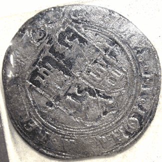
Wreck of the 300 - On April 9, 1554, four Spanish ships left Veracruz, Mexico, for home, but only one made it past Padre Island. On April 29, a storm hit, and three ships, the San Esteban, Espiritu Santo, and Santa Maria de Yciar ran aground on the sand bars. Three hundred and the four hundred people on the voyage died. Of the survivors who made it off the ship, more hardships were to come. The local Karankawa Indians offered food as assistance, then attacked them. When news of the shipwrecks reached Spain, a salvage mission was sent. There had been $9.8 million worth of treasure on those ships. Over thirty-five thousand pounds of treasure were found, but fifty-one thousand still waits at the bottom of the Gulf of Mexico. Modern salvage efforts began in the 1960s.
Photo above: Existing buildings of the Novillo Line Camp ranch. Courtesy National Park Service. Below: Sand dunes reaching toward the Gulf of Mexico at Padre Island National Seashore. Courtesy National Park Service.

Padre Island Now
It's not far from Corpus Christi, and no, it's not the South Padre Island known more for Spring Break. This is North Padre Island and a shoreline so long and wonderful, you'll spend countless hours just wandering up and down it. Too far south and you'll need your feet or a four wheel drive vehicle. At one time, Father Jose Nicolas Balli', i.e. Padre Balli' and the name, owned the island, served as missionary priest, and finance director of the missions in the entire Rio Grande Valley. The land had been granted to his grandfather in 1759 by the King. He would ranch it and that legacy would continue after he was gone.
Today, you'll be entering the park from the north where the Malaquite Visitor Center sits around Milepost 0, not far from one of the legacy ranches. It's actually a bit inside the actual entrance, but this is the area most people focus around. For the majority, it's the beach that brings them for fishing, sunbathing, and water activities. For some, it's those sea turtles and being there at the perfect time the hatchlings hatch and make their way to the water. No matter why you come, you'll marvel at the vistas over the Gulf of Mexico, or for some, that marsh water on the Gulf Intercoatal Waterway side, Laguna Madre, that has all those birds.
Very little of the past can be seen in the park. Yes, the Novillo Line Camp is there, but not open for visitation. Those shipwrecks still sit in the water, but not viewable for the regular public. Now the pleasures of the park go further back to the beach, Gulf of Mexico, the variety of birds that wade through the estuary and marshes and take flight in flock. And the Kemp's ridley sea turtle, one of five species that ply the Gulf of Mexico, have become one of its stars. They are the smallest of the gulf sea turtles, on average around 25 inches long as adults. They come ashore every two years to lay eggs; each female can lay hundreds of eggs in one season.
T-Shirts and Souvenirs

Padre Island National Seashore T-Shirts and Souvenirs from the official merchandise of America's Best History.

Padre Island
Things You Should Not Miss
1. Watch a Hatchling Release. These are sporadic releases between June and October, 6:45 a.m., and usually located in front of the Malaquite Visitor Center. There is no schedule; they occur when the nests hatch. If you want to know more, call the Hatchling Hotline 361-949-7163.
2. Camp on the beach. The entire south beach, needing a Four Wheel Vehicle, or walk-in, is open to primitive camping. The other campgrounds, most near the north entrance station and Visitor Center, have more amenities, but are just as close to all that nature.
3. Orient yourself to the park by visiting the Malaquite Visitor Center and take in a ranger guided tour by walking the beach or talk on the observation deck, if available.
Photo above: An estimated three hundred and seventy-three thousand western sandpipers taking flight on Laguna Madre. Source: National Park Service.
Visitor FAQ
What's There Now
Padre Island National Seashore
Malaquite Visitor Center - Milepost 0, includes a small museum, information desk with ranger orientation, observation tower, restrooms, cold rinse showers, and picnic pavilions. There's also a bookstore and free ranger programs.
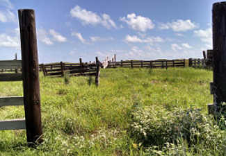
The Line Camps - Novillo, Black Hill, and Green Hill were part of the Dunn family ranch spread fifteen miles apart on the island. There's not much left of Black Hill and Green Hill except some fencing, but at Novillo, there's a well, bunkhouse, wind mill, other small buildings, and corrals. You can only see that from the dunes, not close up.
Yarborough Pass - Milepost 15. Dredged in 1941 after a large fish kill in 1938 due to salinity in the Laguna, the pass allowed the less salty gulf water to dilute it. Over time, the pass filled in, was redredged, and now has been completely overtaken by beach again.
Little Shell Beach (Milepost 10-15) and Big Shell Beach (Milepost 20-25) - Currents meet and deposit shells of differing sizes along these two beaches.
Grasslands Nature Trail - Near entrance station. Only three quarters of one mile long, but home to great views of birds, grasslands, and the dunes. Over four hundred species of birds have been viewed in the park.
South Padre Island - No, this is not in the park, but it is close by. You can't access it from the park itself, but from Port Isabel and the Queen Isabella Causeway. Although the town has a winter population of around three thousand, it swells during spring break and summer with tourists. There are hotels, condos, campgrounds, and beach homes here to rent.
Photo above: Fencing and corrals at Novillo Line Camp, Padre Island National Seashore. Courtesy National Park Service.

Directions to the Park
From Corpus Christi. Thirty-one miles from the city and a little over one half hour in time, take Texas 286 South for 4 miles to Texas 358 East for 10 miles. Continue across the John F. Kennedy Causeway, then south on South Padre Island Drive/Park Road 22 to the park entrance. For more complete direction, check your GPS and map program.
Lodging and Camping
No lodging in the park. For nearby hotel/motel lodging near the north entrance station and Corpis Christi, check one of your favorite hotel/motel sites for the choice that's right for you. For those that want the spring break experience or more man-made experience, check the South Padre Island choices.
There are five campground areas within Padre Island National Seashore.
Malaquite Campground - Half mile north of the Visitor Center. 48 sites with picnic tables; some with overhead canopies. No hookups, but there are restrooms and cold rinse showers. Fee required.
Photo above: One dowitcher looking for food at the park. Source: National Park Service.
Bird Island Basin - Laguna Madre near boat launch. Chemical toilets. RV and tent camping allowed. Fee required.
North Beach - Northernmost section of park. Primitive camping. Free permit required. RV and tent camping allowed.
South Beach - South end of Closed Beach to Mansfield Channel. Primitive camping. Free permit required. No paved road, must drive or walk on the beach. Four wheel drive necessary. Chemical toilet at entrance.
Yarborough Pass - Laguna Madre 15.5 miles south of Visitor Center. Primitive camping. Free camping permit required. Four wheel drive vehicle needed.
One piece of treasure from the shipwrecks off the coast of the park. This artifact was minted between 1542 and 1572. Image courtesy National Park Service.
