-
Pictured Rocks National Lakeshore
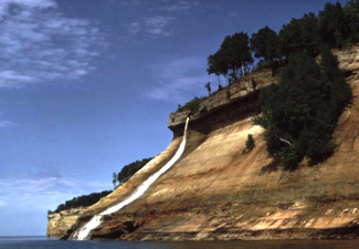
Just one of the many waterfalls, Bridalveil Falls, that travels down the cliffs into Lake Superior at Pictured Rocks National Lakeshore. Source: National Park Service.
Associate Pages
-
Visitor Statistics
953,052 visitors
Pictured Rocks National Lakeshore
#82 Most Visited National Park Unit
Source: NPS, Rank among 398 National Park Units 2024.
Park Size
35,729 acres (Federal); 37,507 acres (Total)
Park Fees
Free
Au Sable Lighthouse Tour - $3.
Fees subject to change without notice.
Weather
Upstate Michigan, Great Lakes weather. Pleasant summers with highs in the 70s and lows in the 50s. Snowfall from late November to late April, totalling 140 inches per year.


Photo above: Historic photo of Chapel Rock prior to rockfall disconnecting it from the mainland. Right: Miners Castle from Lake Superior at Pictured Rocks National Lakeshore. Photos courtesy National Park Service.

Pictured Rocks National Lakeshore
It's been around for fifty years now, the first of its kind, the National Lakeshore kind, when originated in 1966. Pictured Rocks on Lake Superior began a trend in the designation that became, in many ways, Michigan's answer to the National Park. Sometimes odd the way the National Park Service designates their lands, as most overlap between nature and history, beauty and accomplishment. That's certainly true here in the going north area of Michigan. You have history in the buildings and waterways of lighthouses and navigation, and then you have those cliffs and waterfalls that create pictures on rocks.
Sponsor this page. Your banner or text ad can fill the space above.
Click here to Sponsor the page and how to reserve your ad.

Pictured Rocks Then
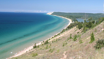
For fifteen miles above Munising, Michigan, sandstone cliffs, some two hundred feet high, rise above Lake Superior and form the genesis for Pictured Rocks. These were dangerous cliffs and waters for travelers, from the past, i.e. 1658 trapper Pierre Esprit Radisson to the more present, like the famous 1975 shipwreck of the Edmund Fitzgerald, and many more boats that would wreck off its coast. That's where those lighthouses came in and the United States Coast Guard plied their mission. For those coming today for recreation and history, you can visit many visitor centers and lighthouses dedicated to telling that story. For others, you can visit the many waterfalls that rage over the Pictured Rocks into the lake, or the Grand Sable Dunes, a two hundred and seventy-five foot dune that rises above the lake. Try climbing that one; it ascends at a thirty-five degree angle.
Logging History - After the fur traders traversed the waterways and settlements began to sprout up along the lake, the logging industry, which had exhausted the white pines of New England by the 1840s while building the nation, sought new supplies. Michigan provided that. The first logging in the Pictured Rocks zone began in 1877 by Joseph Weller; by 1879, he shipped 150,000 cubic feet of wood. By 1882, Weller's operation was surpassed with Thomas G. Sullivan. In three years, Sullivan cut 50 million feet of white pine.
The United States Coast Guard and Grand Marais - Shipping increased dramatically after the Sault Locks were opened in 1855. There were 193 passages that year; 3,503 by 1880. By 1895, a light was installed to assist navigation with a light saving station under construction by 1898, manned by the U.S. Life Saving Service until 1940. Shipwrecks during their time included the 1912 South Shore, the 1919 H.E. Runnels, and the 1939 Lydia. The USCG Grand Marais opened in 1938 and was in use until 1981. During the time of the USCG Grand Marais, the shipwreck of the 729' Edmund Fitzgerald occurred on November 10, 1975.
Au Sable Light Station - Built from 1873 to 1874, the Au Sable Light stands eight-seven feet tall with a fog signal building added in 1897. The head lightkeeper's house dates back to 1909. Au Sable guards the coast twelve miles west of Grand Marais.
Photo above: Historic image of Munising Range Light Station and the Front Range Light. Source: National Park Service. Photo below: Little Portal Point heading west on Lake Superior. Source: National Park Service.
Pictured Rocks Now
Pictured Rocks National Lakeshore - It became the first national lakeshore after a decade of study into how the lake area of Michigan could be added to the National Park Service. By 1966, the park had been authorized in two zones; the public lakeshore zone and and inland area still owned by private sources. The park opened officially on October 6, 1972.
The buildings of many lighthouses and life saving stations are still there for you to visit. Grand Marais now serves as a Ranger Station with a Lightkeepers House Museum in the keepers quarters. You can get a guided tour of the Au Sable Light Station, one and one half mile walk each way required past shipwreck ruins on the beach below the trail, hike a huge dune with sand blown from the Lake Superior beach to a height of two hundred and seventy-five feet, and watch water tumble over the cliffs in a variety of waterfalls that will marvel the nature inclined.
Buy Chronology

T-Shirts and Souvenirs

Pictured Rocks National Lakeshore T-Shirts and Souvenirs. Official gear from America's Best History or your favorite historic site or national park.

Pictured Rocks
Things You Should Not Miss
1. Check with a Visitor Center and find out what programs the rangers are giving during your stay. They don't update the website as often as they should, but the programs are great, whether they be the guided tour of the Au Sable Light Station or an amphitheater evening talk at Twelvemile Beach. Some years, they have a car caravan Waterfall tour on special days.
2. Take a boat tour. A concessionaire at Picture Rocks takes you on a thirty-two mile, up to two and one half hour trip on Lake Superior, narrating your path past all those cliffs, shipwrecks, and lighthouses. It operates from mid-May to mid-October from the Elm Avenue city dock in Munising. Sometimes in the summer, a park ranger narrates the way back. Prices are $38-45/adult; $10/kids 6-12; $1/Under 6. Fees subject to change without notice.
3. Search for shipwrecks. Although most of the shipwrecks along the Pictured Rocks Lake Superior coast can only be seen by boat, a few, including one near Hurricane River, can be beach walked to. Now that's just plain cool.
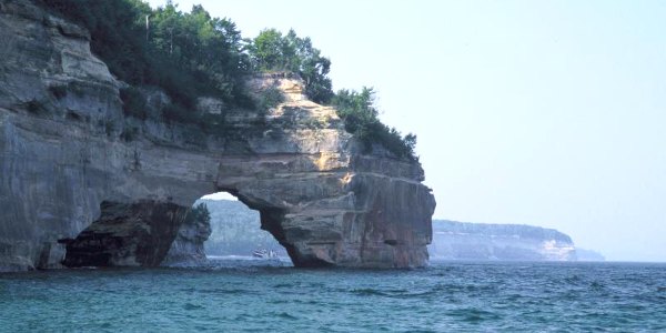
Photo above: Grand Portal Point at Pictured Rocks. Source: National Park Service.
Visitor FAQ

What's There Now
Pictured Rocks National Lakeshore
Six Visitor Centers
Grand Sable Visitor Center (East Entrance) - Eastern gateway to park near North Country National Scenic Trail. Park orientation and bookstore. Open daily summer season, some weekends May, September, and October.
Pictured Rocks/Hiawatha Forest Interagency Visitor Center (Munising) - Open daily summer season; daily except Sundays winter season. Exhibits, bookstore, and interpretive activities.
Minising Falls Visitor Center (West Entrance) - Wayside exhibits, ranger orientation, bookstore, and access to the North Country National Scenic Trail. Open mid-June to mid-September.
Miners Castle Information Center (Central) - Wayside exhibits, ranger orientation, small bookstore, and access to the North Country National Scenic Trail. Open mid-June to mid-September and some spring and fall weekends.
Au Sable Light Station Visitor Center (East) - Exhibits and guided tours mid-June to mid-September from Wednesday to Sunday.
Lakeshore Headquarters at Sand Point (West) - Open year round Monday through Friday in Munising U.S. Coast Guard Station. Boathouse with maritime exhibits and nearby Sand Point Marsh Trail.
Grand Marais U.S. Coast Guard Station and Grand Marais Harbor of Refuge - Ranger station located at far east end of park in the guard station with Lightkeepers House Museum in the Harbor of Refuge.
Beaches, shipwrecks, and additional lighthouses.
Photo above: Current image of Au Sable Light Station. Source: Wikipedia Commons.

Trails to Hike
There are a variety of trails in the park, including the North Country National Scenic Trail, nature trails, and great day hikes.
Nature Trails - Miners Falls Nature Trail (1.2 miles, 77 steps); Sand Point Marsh Trail (0.5 miles, marsh boardwalk); White Birch Trail (2 miles, Twelvemile Beach Campground); and White Pine Trail (0.7 miles, Little Beaver Lake Campground, 250-300 foot tall white pines).
North Country National Scenic Trail - Located in seven states, forty-two miles of the trail pass through Pictured Rocks National Lakeshore with backcountry campgrounds along the way.
Variety of other day hikes available - Ask for a map at one of the Visitor Centers.
Lodging and Camping
While there is no traditional lodging within Pictured Rocks National Lakeshore, except developed and backcountry camping, there are a variety of lodging choices in the communities nearby. Check out your favorite online lodging site for the motel, hotel, or bed and breakfast of your choice. Campgrounds fill quickly in summer. Other campgrounds outside the park are available.

Developed camgrounds.
Little Beaver Lake Campground (Central) - Twenty miles northeast of Munising. Eight campsites, no hookups, boat launch.
Hurricane River Campground (East) - Twelve miles west of Grand Marais on Lake Superior. Twenty-one campsites, no hookups.
Twelvemile Beach Campground (East) - Fifteen miles west of Grand Marais. Thirty-six sites, no hookups.
Backcountry Camping - Specific locations at two to five mile intervals along trails. Small fee and permit required. Reservations acceptable.
Photo above: Mosquito Beach at Pictured Rocks National Lakeshore. Source: National Park Service.
Photo above: Sand Point Beach along Lake Superior at Pictured Rocks National Lakeshore. Photo courtesy National Park Service.

Get Baseball History and Books at Stat Geek Baseball, including Fields of Gold, Baseball's Best Glove Work.