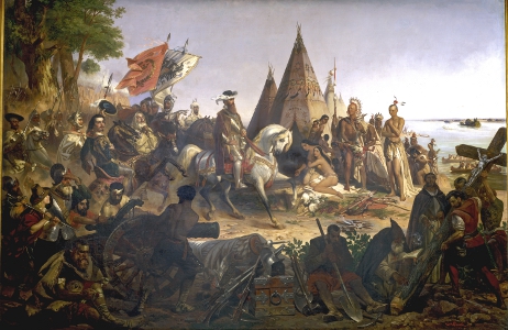
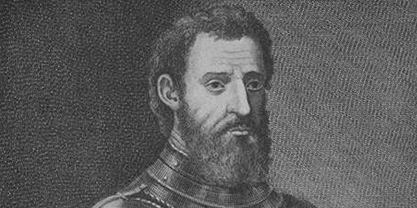
Above: Painting, entitled Discovery of the Mississippi, by William H. Powell, 1847, is located in the Rotunda of the Capitol in Washington, D.C. Right: Giovanni de Verrazzano, 1889, engraving by F. Allcarini, Tocchi, courtesy Wikipedia Commons.
Sponsor this page for $75 per year. Your banner or text ad can fill the space above.
Click here to Sponsor the page and how to reserve your ad.
-
Timeline
Detail - 1529
April 22, 1529 - The Treaty of Zaragosa (Zaragoza, Saragossa) attempts to clarify the Treaty of Tordesillas from 1494 between Spain and Portugal. Again this treaty attempted to clarify previous boundaries agreed between only two nations, Spain and Portugal, plus earlier boundaries by the papacy. All lands would still be divided between the two nations, with the Philippines and North America to Spain, and the Moluccas to Portugal.

For the thirty-five years since the Treaty of Tordesillas had been signed, it was obvious that the original treaty did not accurately account for lands found on the other side of the world, making the ships of discovery by Portugal and Spain subject to passing themselves in the middle of the night and claiming the same lands. Of course, neither treaty, it should be noted up front, accounted for the rest of the world and their eventual exploration goals. But for the period of time in the late 15th and early 16th centuries, that point was moot, or at least subverted, by the fact the Spain, Portugal, and the Vatican were in control of the seas and the conquest of the New World.
The Treaty of Tordesillas had cut the world in two; there was a meridian placed in the Atlantic Ocean, giving Spain the land to the west and Portugal the land to the east. But alas, what about the Pacific Ocean, not yet found by European explorers at the time of the 1494 treaty. This would change. And when it did, an anti-meridian, another line, would be needed.
In 1511, an expedition by Portuguese explorer Afonso de Albuquerque had conquered Malacca, his conquest of the avenues to the Indian Ocean from Europe predominantly complete. By 1512, his understudy, Antonio de Abreu, had reached the Bandu Islands of Malaysia, known as the Spice Islands. In 1522, the Portuguese would make an agreement with the locals to build a stone fort and factory, Forte de Sao Joao Baptista de Ternate, in eastern Indonesia, part of the Sultanate of Ternate. At some point during these years, a cousin or friend of Magellan (who himself was trying to convince the Spanish to finance his circumnavigate the globe tour), the contact who had been part of the Portuguese exploration, wrote him about the islands. Magellan wanted to go.
Magellan and the Maluccas Controversy
Ferdinand Magellan had been trying to convince the Spanish to finance a voyage west from Spain since 1517 in order to establish the spice route Columbus had promised, but he didn't want to disturb the Portuguese and their eastern route through the Indian Ocean. Finance secured from Charles I, King of Spain, future Charles V, of the Holy Roman Empire, Magellan and his five ships had left Sevilla on August 10, 1519, reaching Malaysia's "spice islands" two years later on November 6, 1521, although Magellan himself had not made it, killed in the Philippines that April.
A problem brewed, particulary after Charles V sent a second expedition in 1525 under Garcia Jofre de Loaisa to colonize the spice islands for Spain, assuming that the islands were in Spanish territory according to the Treaty of Tordesillas. That expedition of seven ships, the second naval expedition to cross the Pacific Ocean, arrived in the islands in September 1526 with one ship. They docked in Tidore and built a Spanish fort. Inevitable battles ensued.

How the Conflict Was Resolved
Even prior to the arrival of the second ship and establishment of the fort at Tidore, Spain and Portugal had decided, in 1524, to appoint a Junta de Badajoz-Elvas, with three astronomers/mapmakers, three pilots, and three mathematicians. They were charged with finding the exact location of the meridian established in the Treaty of Tordesillas. After meeting several times, no agreement could be reached. Both had their own maps showing the Maluccas, islands west of New Guinea including Ternate, Tidore, Moti, Makian, and Bakan, to be on their side of the line. One year later, on February 10, 1525, the problem began to see a solution; Catherine of Austria, Charles V's sister, married John III of Portugal and a year after that, March 11, 1526, Charles V himself married King John's sister Isabella of Portugal.
It took several years to finalize the arrangements, but on April 22, 1529, the Treaty of Zaragosa was completed. Its main tenants were to establish an eastern border to the domain zone at 297.5 leagues or 17 degrees east of the Malucca islands near the Marianas. This gave the Maluccas to the Portuguese; in exchange the Portuguese gave the Spanish 350,000 ducats. "All rights, actions, ownership, ownership and possession or almost possession and all rights to navigate, contract and trade in the Maluco" was part of the agreement. The agreement also banned the Portuguese from expanding the fort at Ternate; they could only repair it.
The anti-meridian line did not accomplish something the Spanish contended they wanted; equal hemispheres of influence, the Portuguese won that battle, 191 degrees to 169 degrees. Basically Portugal got most of Asia; Spain got the Pacific Ocean.
The agreement could be dismantled, if wanted, by the Emperor, by returning the money, but he never did that. Charles V needed Portuguese money to battle his arch rival, France, in the War of the League of Cognac.
Image above: Map of the Colonial demarcation lines between Spain and Portugal from the Treaty of Tordesillas and Treaty of Saragosa, 2007. Courtesy Wikipedia Commons. Image below: Portuguese Fort of Saint John Baptist of Ternate, 1720, assumed unknown Dutch artist. Courtesy Wikipedia Commons. Source info: Spanish Magazine of the Pacific, Spanish Association of Pacific Studies (AEEP), No. 4. Year IV. January-December 1994; "Treaty of Tordesillas"; Wikipedia; Guampedia.com.

History Photo Bomb


Christopher Columbus, by Ridalfo Ghirlandaio, 1520. Courtesy Wikipedia Commons.
ABH Travel Tip
Much of America's best history takes in the beauty and nature of our national parks. From the first park in Yellowstone, from the coast of Maine to the shores of Hawaii Volcanoes, check out the history of the USA as made by our land.