They came, in colonies settled around Jamestown, with the
pilgrims at Plymouth Rock in the Massachusetts Bay, and they began what we would term the America of today. There would be treaties with the Indian nations and battles amongst warring tribes. There would be contests of wills between colonies funded and founded by British, Spanish, and French concerns. But this would be the century that began true settlement, for all its wonder and hardship and harbinger of a nation that would come.
March 9, 1669 - Johann Lederer leads expedition from the York River into the Appalachian Mountains at the behest of Colonial Governor Sir William Berkeley, who believed a passage to the west and Indian Ocean only a few weeks away. Lederer becomes the first European to crest Blue Ridge Mountains and see the Shenandoah Valley.
Johann Lederer, a German immigrant for one year, had been chosen by the Governor of the Virginia Colony, during his second term in that post, and a Lord Proprietor of the Colony of the Carolinas, William Berkeley, to trek west through the mountains that rose off the coast with an expedition that might find that elusive path to the Indian Ocean, or at least find California. Berkeley had wanted to make this expedition himself earlier with two hundred men, a two week journey, he thought, at most, but Lord Arlington (granted the entire colony with Lord Culpeper in the early 1670's for thirty-one years), denied that request. Yes, the Indian Ocean and California were further out than both thought.
Berkeley contracted Lederer to make the journey for him, but without those two hundred men. Lederer, with only three Indian men (Magtakunh, Hopottoguoh, and Naunnugh) to accompany him, would make this first of three expeditions to discover just what lay beyond the colony horizon. By the end of those travels, he would find much to be pleased with. The Shenandoah Valley and Allegheny Mountains, with all their riches, were just over the Crest of the Blue Ridge. The Indian Ocean was not.
Lederer was an accomplished man, even though only twenty-five, speaking four languages, but not much English, and a physician by trade. For fifteen days from March 9-24, Lederer and his small party explored the mountains from his starting point of Chickahominy, an Indian village at the falls of the York River. He was astonished by the size of a Rattlesnake, two and one half yards long, who had eaten a squirrel whole. He wrote of the wildlife seen (bear, deer, leopards) and rivers crossed, Pamunkey and Mataponi for two, before cresting the Blue Ridge and sighting the Appalachian Mountains for the first time on March 14. The next day they crossed the south branch of the Rappahannock River (today's Rapidan). Lederer climbed into the mountains (thought to be the Southwest Mountains between Charlottesville and Orange) over the next several days, but could not find the passage to India before returning home.
Lederer would go on two further expeditions over the next year. He wrote a report, drew maps, identified Indian villages, and prepared coming explorers and settlers for the topography ahead.
By the end of this third journey, Lederer did not believe that the Indian Ocean or California was only an eight or ten day journey from the Atlantic. He was also not feted properly by the residents of Tidewater Virginia, with some noting jealousy that these expeditions were conducted by a German, and not an Englishman.
Lederer's Report - Opening
Below is transcribed from the original translation, with some liberties to grammer and spelling.
A General and Brief Account of the North American Continent
North, as well as South America, may be divided into three Regions: the Flats, the Highlands, and the Mountains. The Flats, (in Indian, ahkynt) is the territory lying between the Eastern Coast and the falls of the great Rivers, that there run into the Atlantick ocean, in extent general taken Ninety miles. The Highlands (in Indian, ahkontshuck) begin at those falls and determine at the foot of the great ridge of Mountains that thorow the midst of this Continent, Northeast and Southwest, called by the Spaniards Apalataei, from the Nation Apalakin; and by the Indians, Paemotinck. According to the best of my observation and conjecture they lie parallel to the Atlantick Sea coast, that bearing from Canada to Cape Florida, Northeast and Southwest, and then falling off due West as the Mountains do at Sara; but here they take the name Suala; Sara in the Warrenuncock dialect being Sasa or Sualy.
Lederer's Report - Appalachian Mountains
The Apalataean Mountains, called in Indian Paemotinck, (or the origine of the Indians) are barren rocks, and therefore deserted by all living creatures, but Bears, who cave in the hollow Cliffs. Yet do these Mountains shoot out to the Eastward great promontories of rich land, known by the high and spreading trees which they bear; these promontories, because lower than the main ridge, are called by the Indians Tanx Paemotinck) alias Aquatt). To the North east the Mountains rise higher; and at Sara they sink so low that they are easily passed over, but here (as was said before) they change their course and name, running due West and being called Sualy; now the Sualian Mountains rise higher and higher Westward.
Of the Manners and Customs of the Indians Inhabiting the Western parts of Carolina and Virginia.
The Indians now seated in these parts are none of those which the English removed from Virginia, but a people driven by the enemy from the Northwest, and invited to sit down here by an Oracle above four hundred years since, as they pretend: for the ancient inhabitants of Virginia were far more rude and barbarous, feeding only upon raw flesh and fish, until these taught them to plant corn, and shewed them the use of it.
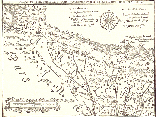
Image above: Map of the Lederer Expedition, the Discoveries of John Lederer, 1672. Courtesy Library of Congress, Hathitrust, Virginiaplaces.org. Below: The Valley of the Shenandoah, 1864, Currier and Ives. Courtesy Library of Congress. Info source: "The Discoveries of John Lederer, 1869-1870," 1872, Translated by William Talbot, Hathitrust, Library of Congress; Wikipedia; Virginiaplaces.org; "Creating Virginia: The Role of John Lederer in the transition of western Virginia from a wilderness into a colony," 2006, Richard Jason Burns, West Virginia University.
History Photo Bomb
Map of the Lederer Expedition, the Discoveries of John Lederer, 1672. Courtesy Library of Congress, Hathitrust, Virginiaplaces.org.
Jacques Marquette and Louis Jolliet in a drawing of their canoe voyage of exploration in 1673, 1911, Edgar S. Cameron. Courtesy Library of Congress.
ABH Travel Tip
You can visit much of the Pre-Revolution history of the United States throughout the many trails and historic sites of the nation. And don't miss out on the Native American history throughout Florida or other regions. The history of the nation and North America comes from the culture of the many tribes that made up the mosaic of human culture in each state. They were here before the majority of us, after all, and their history is an amazing collection of wonder, beauty, and dedication to the land that sits beneath us.
Drawing depicting the capture of Mrs. Rolandson during the King Philip's War between colonists and New England tribes, 1857, Harper's Monthly. Courtesy Library of Congress.