Click here to Sponsor the page and how to reserve your ad.
-
Timeline
1828 Detail
January 12, 1828 - The Treaty of Limits with Mexico goes into effect.
It would be the first treaty consummated between the rather newly freed United Mexican States. And yes, the subject, as in most treaties, would have to do with the border between the nations, a border still, in other ways, contested today. Today, however, it has to do with the construction of a wall to keep citizens of both nations confined to their side, at least without documentation. The border had previously been established in 1819 when Spain, then in ownership of the Mexican territories, when it concluded the Adams-Onis Treaty of 1819. There was a desire to establish a more permanent document, since the original Adams-Onis had been with Spain, and the impetus for it, the purchase (five million dollars for property damage in various conflicts) of Florida from Spain by the United States was no longer the rationale. Yes, it had been a confusing time along the southern border. The governments of the now United Mexican States and the United States wanted to have their own dotted i's and t's so clarity could reign and no conflicts arise in the future over the border. Well, best laid plans, because within decades, after amendments and alterations, that did not work anyway.
It took until April 5, 1832 for the Treaty of Limits to go into full effect. Only four years later, 1836, the Republic of Texas was independent of Mexico, and the United States would recognize their sovereignty. Mexico thought that recognition was a breach of the Treaty of Limits. When the recognition of the Republic of Texas became the annexation of the Republic of Texas by the United States in 1845, it would lead to the Mexican-American War.
How the United Mexican States Came to Be
On September 27, 1821, Mexico gained its independence from Spain. It had taken eleven years of war to alter the three centuries of Spanish domination in Mexican territory. They would be sovereign from that date, with the Treaty of Cordoba signed, and known as the Mexican Empire. They would be ruled, initially, by a Constituent Congress and an Emperor, chosen May 18, 1822, Agustin de Iturbide, the general who had led the war for independence. The Congress and the Emperor had their problems, with the Emperor dissolving the Congress, other generals including Santa Ana voicing their objection, the Congress reinstated, and Iturbide abdicating by March 19, 1823. But the newly restored Congress did not accept his abdication, so by April 8, 1823, the entire first attempt at Mexico dissolved. A new Constitution was written in 1824. Eventually, eleven years later in 1835, that would be suspended by soon to be dictator Santa Ana. What a mess.
Through that chaos, the first imperial Mexican government was still focused on the border with the United States. On October 31, 1822, the Minister to the United States from Mexico under Iturbide was told in secret instructions that the Mexican government still considered the 1819 Adams-Onis boundaries to be in place. There was distrust between the nations over the territory of Texas, with some considering the purchase of Louisiana from France as inclusive of that territory in the USA favor. Mexico pursued the Treaty of Limits with all that knowledge in vogue; it was unclear what the government of the United States would do in the years after 1822, as negotiations, if you could conclude them as such, continued toward the eventual treaty.
Full Text, Treaty of Limits 1828
Treaty of Limits, Between the United States and the United Mexican States
The limits of the United States of America with the bordering Territories of Mexico having been fixed and designated by a solemn treaty, concluded and signed at Washington, on the twenty-second day of February, in the year of our Lord one thousand eight hundred and nineteen, between the respective Plenipotentiaries of the Government of the United States of America, on the one part, and of that of Spain on the other: And whereas, the said treaty having been sanctioned at a period when Mexico constituted a part of the Spanish Monarchy, it is deemed necessary now to confirm the validity of the aforesaid treaty of limits, regarding it as still in force and binding between the United States of America and the United Mexican States:
With this intention, the President of the United States of America has appointed Joel Roberts Poinsett their Plenipotentiary ; and the President of the United Mexican States their Excellencies Sebastian Camacho and Jose Ygnacio Esteva:
And the said Plenipotentiaries having exchanged their full powers have agreed upon and concluded, the following articles:
ARTICLE FIRST.
The dividing limits_of the respective bordering territories of the United States of America and of the United Mexican States, being the same as were agreed and fixed upon by the abovementioned treaty of Washington, concluded and signed on the twenty-second day of February, in the year one thousand eight hundred and nineteen, the two high contracting parties will proceed forthwith to carry into full effect the third and fourth articles of said treaty, which are herein recited, as follows:
ARTICLE SECOND.
The boundary line between the two countries, west of the Mississippi, shall begin on the gulf of Mexico, at the mouth of the river Sabine, in the sea, continuing north along the western bank of that river, to the 32d degree of latitude; thence, by a line due north, to the degree of latitude where it strikes the Rio Roxo of Natchitoches, or Red river; then, following the course of the Rio Roxo westward, to the degree of longitude 100 west from London, and 23 from Washington; then, crossing the said Red river, and running thence by a line due north, to the river Arkansas; thence, following the course of the southern bank of the Arkansas, to its source, in latitude 42 north; and thence, by that parallel of latitude, to the South sea: the whole being as laid down in Melish's map of the United States, published at Philadelphia, improved to the first of January, 1818. But, if the source of the Arkansas river shall be found to fall north or south of latitude 42, then the line shall run from the said source due south or north, as the case may be, till it meets the said parallel of latitude 42; and thence, along the said parallel, to the South sea. All the islands in the Sabine, and the said Red and Arkansas rivers, throughout the course thus described, to belong to the United States; but the use of the waters, and the navigation of the Sabine to the sea, and of the said rivers Roxo and Arkansas, throughout the extent of the said boundary on their respective banks, shall be common to the respective inhabitants of both nations.
The two high contracting parties agree to cede and renounce all their rights, claims, and pretensions to the territories described by the said line; that is to say: the United States hereby cede to his Catholic Majesty, and renounce forever, all their rights, claims, and pretensions to the territories lying west and south of the above described line; and, in like manner, his Catholic Majesty cedes to the said United States all his rights, claims, and pretensions to any territories east and north of the said line; and for himself, his heirs, and successors, renounces all claim to the said territories forever.
ARTICLE THIRD.
To fix this line with more precision, and to place the landmarks which shall designate exactly the limits of both nations, each of the contracting parties shall appoint a commissioner and a surveyor, who shall meet before the termination of one year from the date of the ratification of this treaty, at Natchitoches, on the Red river, and proceed to run and mark the said line, from the mouth of the Sabine to the Red river, and from the Red river to the river Arkansas, and to ascertain the latitude of the source of the said river Arkansas, in conformity to what is agreed upon and stipulated, and the line of latitude 42, to the South sea. They shall make out plans, and keep journals of their proceedings; and the result agreed upon by them shall be considered as part of this treaty, and shall have the same force as if it were inserted therein. The two Governments will amicably agree respecting the necessary articles to be furnished to those persons, and also as to their respective escorts, should such be deemed necessary.
ARTICLE FOURTH.
The present treaty shall be ratified, and the ratifications shall be exchanged at Washington, within the term of four months, or sooner if possible.
In witness whereoh we, the respective Plenipotentiaries, have signed the same, and have hereunto afiixed our respective seals.
Done at Mexico, this twelfth day of January, in the year of our Lord one thousand eight hundred and twenty-eight, in the fifty-second year of the Independence of the United States of America, and in the eighth of that of the United Mexican States.
J. R. POINSETT (L.S.)
S. CAMACHO, (L.S.)
J. Y. ESTEVAN, (L.S.)
ADDITIONAL ARTICLE
To the Treaty of Limits concluded between the United States of America and the United Mexican States, on the 12th day of January, 1828.
The time having elapsed which was stipulated for the exchange of ratifications of the Treaty of Limits between the United Mexican States and the United States of America, signed in Mexico on the 12th of January, 1828; and both Republics being desirous that it should be carried into full and complete effect, with all due solemnity, the President of the United States of America has fully empowered, on his part, Anthony Butler, a citizen thereof, and Charge d'Affaires of the said States in Mexico; And the Vice-President of the United Mexican States, acting as President thereof, has, in like manner, fully empowered on his part their Excellencies Lucas Alaman, Secretary of State and Foreign Relations, and Rafael Mangino, Secretary of the Treasury, who after having exchanged their mutual powers, found to be ample and in form, have agreed, and do hereby agree, on the following article:
The ratifications of the Treaty of Limits, concluded on the 12th January, 1828, shall be exchanged at the City of Washington, within the term of one year, counting from the date of this agreement, and sooner should it be possible.
The present Additional Article shall have the same force and effect as if it had been inserted word for word in the aforesaid treaty of the 12th of January, of 1828, and shall be approved and ratified in the manner prescribed by the Constitutions of the respective States.
In faith of which, the said Plenipotentiaries have hereunto set their hands and affixed their respective seals. Done in Mexico, the fifth of April, of the year one thousand eight hundred and thirty-one, the fifty-fifth of the Independence of the United States of America and the eleventh of that of the United Mexican States.
A. BUTLER, (L.S.)
LUCAS ALAMAN, (L.S.)
RAFAEL MANGINO, (L.S.)
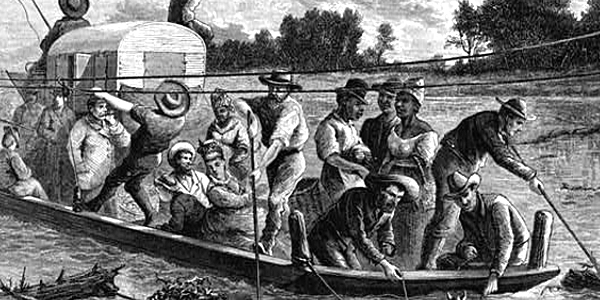
Image above: Engraving of Texas settlers on the Red River, 1874, Robert Hoskins engraving, Frenzeny and Tavernier, Drawing. Courtesy Library of Congress. Image below: Lithograph of General Iturbide entering Mexico City on September 27, 1821, lithograph date unknown, Jimenez Codinach. Courtesy Wikipedia Commons. Source Info: Library of Congress; Wikipedia Commons; Texas and the Boundary Issue, 1822-1829 by William R. Manning, Southwestern Historical Quarterly, Vol. 17 No. 3 (January 1914).

History Photo Bomb

The Smithsonian Institution rises above the Washington, D.C. landscape. Courtesy National Archives.
ABH Travel Tip
The bargains at the National Park Service continue, despite some recent increases in park fees. The National Park Pass is now called the America the Beautiful Pass, which admits all vehicle and family visitors for one year, and costs $80 for one twelve month period. The pass covers most Federal fee areas, including National Parks, Historic Sites, and National Forests. For those of 62 years of age or older, buy the America the Beautiful Senior Pass. For only $20 per year or $80 for a lifetime pass, you gain free
entrance for the rest of your life to all National Parks, National Historic Sites, and National Forests, and other federal fee sites for you, your spouse, and your children, plus discounts of 50% on some use fees, such as camping. Must be purchased in person at a National Fee location, which are the one hundred or so National Park Service sites that charge for entry.

President Andrew Jackson. Courtesy National Archives.
Official Souvenirs
America's Best History

Get history and national park souvenir t-shirts, mugs, stickers, posters, and other gifts from the official gear of America's Best History, now available on Zazzle, Cafepress, Amazon, and Redbubble.

Born this decade, Civil War General and eventual President U.S. Grant begins his history here. Courtesy National Archives.
Timeline Book
