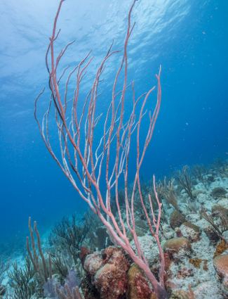
Image above: Sea Whip at Salt River Bay, Susanna Pershern. Courtesy National Park Service.
Spotlight on Lesser Known History
Salt River Bay, U.S. Virgin Islands

T-Shirts and Gifts from the official souvenirs of Americasbesthistory.com.
America's Best History Spotlight
On this page we're going to Spotlight the lesser known historic sites and attractions that dot the history landscape across the USA and are worth a visit if you're in their area. And while they may be lesser known, some are very unique, and will be that rare find. You'll be, at times, on the ground floor, or maybe even know something others don't. It'll be fun. Visit them.
Salt River Bay, U.S. Virgin Islands
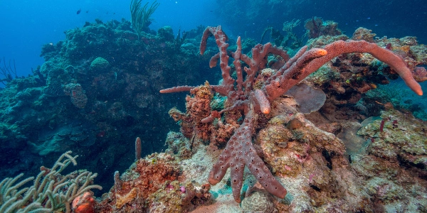
It was indigenous to the tribes of St. Croix and the other Virgin Islands, including the Igneri, Taino, and Carib, the spectacular region of Salt River Bay, that is, until November 14, 1493 came and the second voyage of Columbus began to explore the cove. Yes, for European history, and today, American history, Salt River Bay, with its National Historical Park and Ecological Preserve telling the story of the land, the ocean, the bay, the indigenous cultures, and the fact that it is the only spot in the territories, including states, of the United States, where the men of Christopher Columbus set foot. You can argue whether that was good or not. Photo above: Underwater scene at Salt River Bay, Susanna Pershern. Courtesy National Park Service.
Info, What's There Now, History Nearby

Salt River Bay
While from a history standpoint, the European claim to fame is that landing site of Columbus, it's in the nature of its waters and land that Salt River Bay really shines. From the largest remaining mangrove forest in the Virgin Islands to the coral reefs and submarine canyons three hundred and fifty feet deep within its protected waters, the park is a delight for historians as well as scuba divers with enough skill to ply these sites.
For the history minded, there's the site of Taino villages and the excavation site of a ball court, Forts Flamand (Sale) with remaining earthwork fort, the site of the 1645-1665 English Village, English Governor's House, Fort Greig, and the estimated site of the 1493 clash between the Carib's and the Columbus crew. See below a short explanation of that in the book about Dr. Chanca's letter. It was the first recorded battle between the natives of the New World and the Europeans at a site now known as Cape of the Arrow. At the time of the Columbus crew landing, the Taino tribe had been enslaved by the Carib.
Of course, the history here is not too pleasant throughout the colonial period, including those seven changes in empire. The Spanish, after Columbus, effectively eradicated the Caribs. The colonial empires would employ African slaves. The English (1641, 1645-50), Dutch (1642-1645), French (1650-1733), Danish (1733-1917) all attempted a St. Croix colonial empire here after the Spanish with plantings of cotton, indigo, and sugar. It's a living history museum of beautiful nature and what went wrong in the colonial world.
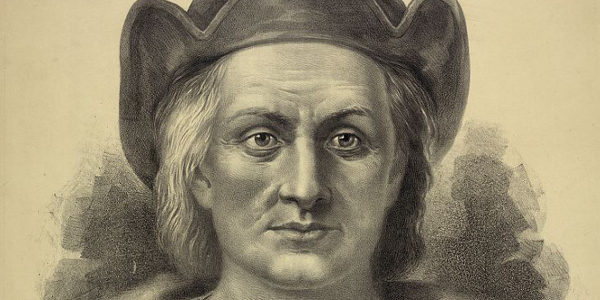
Photo above: Columbus Landing Site, Salt River Bay, 2007. Courtesy Wikipedia Commons. Below: Christopher Columbus, 1892, Currier and Ives. Courtesy Library of Congress.
Where Is It
Salt River Bay National Historical Park and Ecological Preserve is located on the north side of St. Croix, essentially mid-island. It is approximately seven miles east of Christensted on Route 75 East. Give yourself a bit less than one half hour for the travel. Address of the park is 2100 Church Street, Christensted, St. Croix, 00820.
What is There Now
The Visitor Center was damaged during Hurricane Maria and is not currently open as of 2019. The park itself includes over one thousand acres of prehistoric and colonial remnants and ruins, plus the Salt River Bay and its nearby underwater environs of the Caribbean. Snorkeling, scuba diving, kayaking, and hiking tours are available.
When Open and How Much
Open year round. With no contact station currently available on site, you can get information about a visit at the Christensted National Historic Site Visitor Center. There is currently no entrance fee.
Fees subject to change.
Websites
Salt River Bay National Historic Site
Christensted National Historic Site
History Nearby
Well, there's Christiansted National Historic Site on St. Croix, as well as the unique charm of both Christensted itself, as well as Frederiksted on the western side of the island. There's Buck Island Reef National Monument to the north; on St. John, there's the U.S. Virgin Islands National Park, as well as verdant beaches and more on St. John and St. Thomas, where the capital, Charlotte Amalie, is located. Charlotte Amalie includes unique sites such as Blackbeard's Castle, Fort Christian, and Paradise Point, accessed by an aerial tram.
Photos, History, and More Spotlights

Now a National Park
On February 24, 1992, President George H.W. Bush signed legislation establishing the Salt River Bay National Historical Park and Ecological Preserve on St. Croix. The park itself is remote and beautiful, but little visited. In 2018, the national park unit of Salt River Bay drew 4,884 visitors to its site of underwater reefs, historic sites, recreation, plus indigenous and colonial history.
It is jointly managed by the National Park Service and the government of the U.S. Virgin Islands.
Photo above: Scuba Diving at Salt River Bay NHP and Ecological Preserve, Susanna Pershern. Courtesy National Park Service.
Buy Chronology

Great Book for the History Fan with Fifty Short Essays Telling the Story of American History.

How the United States Gained the U.S. Virgin Islands
Well, what is now known as the Virgin Islands started with indigenous Igneri, Taino, Ciboney, Carib, and Arawak tribes, but quickly went sideways once Christopher Columbus named them during his second voyage, landing in the area of the Salt River Bay, on November 14, 1493. It would take awhile, however, for settlement to come. In 1672, the Danish West Indies Company settled St. Thomas, then subsequently St. John in 1694. They became Danish colonies in 1754, including the purchased St. Croix from France. Denmark had unsuccessfully tried to sell the islands to the United States since 1867, and the United States, through its London secretary, Henry White, had tried to buy them in 1899, thwarted by the German Kaiser. White wanted to prevent additional European meddling in the Americas, a notion that became even more prevalent with the beginning of the 20th century.
With the advent of World War I and the USA fearing a submarine base by the Germans on the island, the United States tried again, eventually agreeing to purchase the islands in the Treaty of Danish West Indies. That treaty was finalized on January 17, 1917 for $25 million. It would become an unincorporated United States territory in 1927. Prior to the United States purchasing the Virgin Islands, seven colonial regimes had had their hand at controlling the islands.
Photo above: March 31, 1917 lowering of the Danish flag for the last time at the St. Croix Governer's Mansion, 1917, Orlogsmuseets Archive. Courtesy Wikipedia Commons.
Account of Dr. Chanca Upon Arrival on St. Croix
"On the same day we arrived we left that island (This is the island Columbus named Santa Cruz, but is now known as St. Croix), having being there no more than six or seven hours, and steering for a point of land that appeared to lie in our intended course of travel, we reached it by night. On the morning of the following day we coasted along, but found that although it was very large in extent it was not a continuous territory, for it was divided up into more than forty islets. (This is the land that Columbus would name "the Eleven Thousand Virgins, now known as the Virgin Islands). The land was very high and most of it barren, an appearance which we had never observed in any of the islands visited by us before or since: the ground seemed to me to suggest the probability of its containing minerals."
In the footnotes of the book about Dr. Chanca's letter, written in 1906, "The Letter of Dr. Diego Alvarez Chanca, Dated 1494," the following further explains the landing at Salt River Bay, and subsequently, the remainder of the Virgin Islands. Dr. Diego Alvarez Chanca was the doctor on the second voyage of Columbus to the New World.
"The island to which Columbus gave the name of Santa Cruz, and now known as Saint Croix, where the explorers anchored on Thursday, November 14, 1493. It lies 65 miles east southeast of Puerto Rico, and is 83 square miles in extent. Together with the islands of St. Thomas and St. John, it forms to-day a Danish colony. Here in this island, the most northerly one inhabited by the fierce Caribbees, the Spaniards had their first fight with the Indians in trying to capture a canoe with two women, one man and a boy. Two of the Spaniards were wounded with arrows, and one of them, a Biscayan sailor, died later. The women fought as bravely as the men, and one of them wounded the sailor. He was duly buried on the shore of the island of Haiti, as the Lucayans called Hispaniola or Santo Domingo."
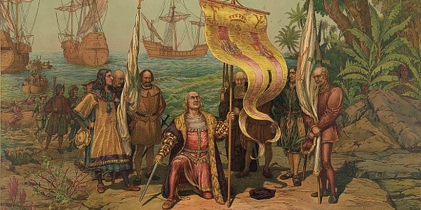
Photo above: Painting Christopher Columbus taking possession of San Salvador, Watling Island by L Prang and Co., 1893. Courtesy Library of Congress. Info Source: "Letter of Dr. Chanca on the Second Voyage of Columbus," American Journeys Collection, Wisconsin Historical Society.

July Spotlight
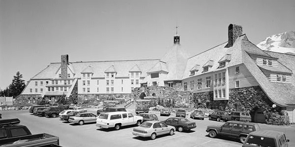
Mohonk Mountain House, New York.
August Spotlight
Kernstown Battlefield, Virginia.