-
Timeline - 2010s
Healthcare reform, a slow economic increase, and an enemy that refuses to go away dominate the first years of the decade as America struggles to find its footing from the economic collapse of 2008 and the international troubles of terrorism and the mideast.
More Timelines

Franklin Delano Roosevelt Memorial, Washington, D.C.
Sponsor this page. Your banner or text ad can fill the space above.
Click here to Sponsor the page and how to reserve your ad.
-
Timeline
Detail - 2012
October 29, 2012 - Hurricane Sandy, taking an unusual track up the East Coast and coming to landfall on the New Jersey coast near Atlantic City and Long Island coasts of New York creates significant damage to coastal towns as well as the boroughs of Manhattan and Staten Island, to the estimated cost of $65.6 billion. The hurricane, at its peak a Category 2 storm, was the largest storm in recorded history by diameter at 1,100 miles.
The storm had been created quickly, forming in the Caribbean only on October 22, 2012 after its impetus as a tropical wave off Africa on October 11. It was not thought to be a significant storm, a typical late season hurricane, at first, and never rose to the Category 4 or 5 which its eventual damage would suggest. However, it grew to be huge, and as noted above, its diameter was the largest in history at one thousand one hundred miles. After its formation, it traveled first across the island of Jamaica (October 24 as a Category 1), Cuba (October 25 as a Category 3), and the Bahamas (October 26 as a Category 1), then, in some ways, hid from forecasters by heading east then straight parallel to the coastline, but not toward it. Eventually, once reaching Virginia, it would make a significant and dangerous turn, tracking west/northwest toward the Mid-Atlantic states on October 28. By the night of the next day, it was striking landfall along the New Jersey coast near Atlantic City (Brigantine) as a post-tropical cyclone.
In 2012, post-tropical cyclones were not noted to be as dangerous as other storms. In fact, warnings and announcements slowed due to its new status. Add to that was the bad fortune that it hit the coasts of New Jersey, New York, and Connecticutt at high tide, causing record storm surges along the ocean, bays, and rivers. Early model forecasts had been wrong, basically showing only one track toward the area hit. It was not until October 26, 2012, that most forecast models were showing Mid-Atlantic landfall.
Hurricane Sandy Hits Landfall
Storm surge was huge; Seaside Heights, New Jersey at 4.4 feet, Sandy Hook, New Jersey at 8.9 feet, Manhattan 4.7 feet, Breezy Points, Queens, New York at 5.6 feet, Oakville on Staten Island 7.9 feet, and all the way up in Boston at 2.6 feet. In Queens, they reached the tarmac and runways of both La Guardia and John F. Kennedy International Airports. While the winds were in the Category 2 Hurricane range, they significantly pushed the disaster of water inundation, ranging in the 50 mph range of sustained winds from New Jersey to Massachusetts, with the highest winds at the eastern end of Long Islands, 65 miles per hour. Maximum winds, of course, were higher; over 90 miles per hour in TOMPKINSVILLE, New York, ISLIP AIRPORT, New Jersey, with the highest at EATONS NECK, New Jersey, at 96 mph. Buoys offshore tracked wave heights; records of 32.5 feet at Buoy 44065 close to shore in northern New Jersey, and further off the coast at Buoy 44025 at 31 feet. Rainfall was not the highest concern, although try telling that to the people in Bellevue, Maryland who got 12.83 inches. Rainfall was significantly higher than even that in the Caribbean where the storm had formed, reaching 28.09 inches in Mill Bank, Jamaica.
Damage estimates were large as well, $50 billion dollars as of one year later, the second largest amount of damages from a cyclone since 1900. There were one hundred and forty-seven deaths; seventy-two in the USA, the most in the northeast since Hurricane Agnes in 1972. Six hundred and fifty thousand homes were damanged or detroyed; power was lost for weeks for up to 8.5 million residents. In Maryland, a large part of the one hundred foot fishing pier was destroyed and beach erosion was extensive. Twenty-two thousand of the three hundred and forty-six thousand homes damaged in New Jersey were uninhabitable. Forty-eight thousand trees were damaged or destroyed in the state. The Casino Pier and Funtown Pier in Seaside Heights was destroyed. Long Beach Island, Union Beach, and Sea Bright were extensively damaged. Jersey City flooded. In New York, three hundred and five thousand homes were destroyed from the storm surge. Years later, debris from the storm would wash up in France.
News Reports
"In Seaside Heights the surge swamps Heiring Avenue, Cartaret, Sampson, Sheridan and Sherman virtually simultaneously. At police headquarters, the floodwaters breach the first floor of the two-story building. Everyone, including roughly 60 residents of Seaside Heights who have taken shelter there, scramble up to the second floor. Boyd (police chief) worries about the generator washing away. It's the only thing powering his department. Hunkered down, the officers and homeowners spend a sleepless night listening to the screeching wind as it claws at the roof trying to pry it off. ... Casino pier, which he calls the anchor of town, is shattered. Debris is everywhere. Yet all across the state, the heavy equipment that will help rebuild New Jersey rumbles forward. At the boardwalk, though - or what's left of it - it's quiet, except for the wind whipping the schredded fabric of Funtown, the ever-present pounding of the waves and the cawing of seabirds as they dip and dive and soar, reeling across the sky as if on some invisible ride." "48 Hours: Before, during, and after Hurricane Sandy," November 4, 2012, Amy Ellis Hunt, Star Ledger, nj.com.
"We are taking a state-by-state look at the devastation caused in the aftermath of Hurricane Sandy, including unprecedented flooding damage in New Jersey and New York City, where the subway system will be shut down for at least four days, as our colleagues report. An interactive map shows where millions of people across the Northeast were still without power on Wednesday and this list outlines transportation and other services that are operating. At least 50 people have been killed during the mammoth storm across the country, including 22 people in New York. ... More than 360,000 people were evacuated over the weekend from low-lying areas along the coast from Old Saybrook to Fairfield amid growing concern about flooding from the hurricane's surge in Long Island Sound." "State by State Guide to Hurricane Sandy," October 31, 2012, Jennifer Preston, Sona Patel, and Maira Garcia, The Lede.
New Jersey Attorney General Jeffrey S. Chiesa filed price-gouging complaints against eight vendors on Friday. As complaints about post-storm price-gouging continue to pile up, New Jersey Attorney General Jeffrey S. Chiesa filed complaints against seven gas stations and a hotel on Friday, accusing them of "exploiting people's misery to make a quick profit." One of the gas stations, a Lukoil in Paterson, increased its price by more than $2 a gallon, to $5.49 from $3.45, after the storm, Mr. Chiesa said. The hotel, a Howard Johnson Express Inn in Parsippany, increased its room rate to $119 from $90, Mr. Chiesa said. The merchants face penalties of $10,000 for a first offense if found guilty. Price gouging is defined as increasing prices by more than 10 percent during an emergency, beyond covering any additional costs brought on by the emergency itself." "New Jersey and New York Start to Address Price Gouging," November 9, 2012, Associated Press.
Minute(s) Walk in History
Hurricane Sandy
Watch the devastation caused to New Jersey, New York, and New England by Hurricane Sandy in October 2012 through video, still, and audio. Sandy was the largest hurricane by diameter on record and came as a surprise to some due to its straddling the line between being a hurricane, a cyclone, and a northeaster.

Prior to Hurricane Sandy, after a tropical cyclone becomes post-tropical, i.e. a northeaster, there were no more announcements or warnings given. This changed in 2013. In addition, prompted by Hurricane Sandy, the National Weather Service began to provide additional date in its forecasts by 2017. Storm surge estimates, in feet above group levels, to help coastal areas prepare, and evacuate, if inundation levels are predicted. Additional weather satellites assist in forecasting, as well, as better warnings about evacuation and preparation. By 2022, track errors had been reduced by one-third.
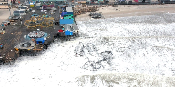
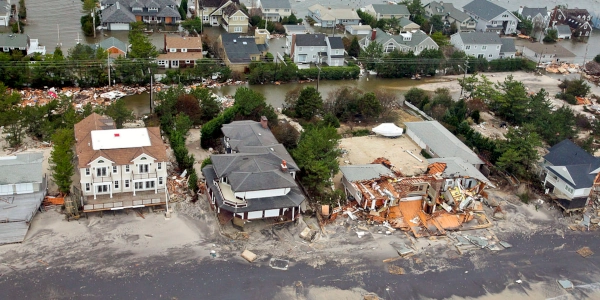
Photo above: Damage to pier and roller coaster in Seaside Heights, New Jersey, 2012, Master Sgt. Mark C. Olsen, U.S. Air Force, Department of Defense. Photo below: Damaged houses in Mantoloking, New Jersey, 2012, Master Sgt. Mark C. Olsen, U.S. Air Force, Department of Defense. Info source: "Hurricane Sandy," National Weather Service; Department of Defense; "Tropical Cyclone Report, Hurricane Sandy," 2013, Eric S. Blake, Todd B. Kimberlain, Robert J. Berg, John P. Cangialosi and John L. Beven II, National Hurricane Center; "After Sandy: Rebuilding and Recovery," National Oceanic and Atmospheric Administration; "Hurricane Sandy Fact Sheet," U.S. Department of the Interior; "Hurricane Sandy Ten Years Later: How a Tragedy Improved Your Forecasts," 2022, Dennis Mercereau, theweathernetwork.com; Wikipedia Commons.
History Photo Bomb

President Barack Obama. Courtesy Wikipedia Commons.
Official Souvenirs
America's Best History


The Statue of Liberty was closed due to Hurricane Sandy until July of the next year; Ellis Island remained closed until 2014.
Buy Chronology

Timeline History

Want a copy of the Timeline. Now available in easy to search
digital format for your Kindle, Nook, or pdf format. Also comes in paperback, too.
ABH Travel Tip

Much of America's best history takes in the beauty and nature of our national parks, plus our seashores and preserves. From the first park in Yellowstone, from the coast of Maine to the tropical reaches of the Everglades and the Big Cypress Preserve, photo above, next door. Check out the history of the USA as made by our land.
In 2012, post-tropical cyclones were not noted to be as dangerous as other storms. In fact, warnings and announcements slowed due to its new status. Add to that was the bad fortune that it hit the coasts of New Jersey, New York, and Connecticutt at high tide, causing record storm surges along the ocean, bays, and rivers. Early model forecasts had been wrong, basically showing only one track toward the area hit. It was not until October 26, 2012, that most forecast models were showing Mid-Atlantic landfall.
Damage estimates were large as well, $50 billion dollars as of one year later, the second largest amount of damages from a cyclone since 1900. There were one hundred and forty-seven deaths; seventy-two in the USA, the most in the northeast since Hurricane Agnes in 1972. Six hundred and fifty thousand homes were damanged or detroyed; power was lost for weeks for up to 8.5 million residents. In Maryland, a large part of the one hundred foot fishing pier was destroyed and beach erosion was extensive. Twenty-two thousand of the three hundred and forty-six thousand homes damaged in New Jersey were uninhabitable. Forty-eight thousand trees were damaged or destroyed in the state. The Casino Pier and Funtown Pier in Seaside Heights was destroyed. Long Beach Island, Union Beach, and Sea Bright were extensively damaged. Jersey City flooded. In New York, three hundred and five thousand homes were destroyed from the storm surge. Years later, debris from the storm would wash up in France.
"We are taking a state-by-state look at the devastation caused in the aftermath of Hurricane Sandy, including unprecedented flooding damage in New Jersey and New York City, where the subway system will be shut down for at least four days, as our colleagues report. An interactive map shows where millions of people across the Northeast were still without power on Wednesday and this list outlines transportation and other services that are operating. At least 50 people have been killed during the mammoth storm across the country, including 22 people in New York. ... More than 360,000 people were evacuated over the weekend from low-lying areas along the coast from Old Saybrook to Fairfield amid growing concern about flooding from the hurricane's surge in Long Island Sound." "State by State Guide to Hurricane Sandy," October 31, 2012, Jennifer Preston, Sona Patel, and Maira Garcia, The Lede.
New Jersey Attorney General Jeffrey S. Chiesa filed price-gouging complaints against eight vendors on Friday. As complaints about post-storm price-gouging continue to pile up, New Jersey Attorney General Jeffrey S. Chiesa filed complaints against seven gas stations and a hotel on Friday, accusing them of "exploiting people's misery to make a quick profit." One of the gas stations, a Lukoil in Paterson, increased its price by more than $2 a gallon, to $5.49 from $3.45, after the storm, Mr. Chiesa said. The hotel, a Howard Johnson Express Inn in Parsippany, increased its room rate to $119 from $90, Mr. Chiesa said. The merchants face penalties of $10,000 for a first offense if found guilty. Price gouging is defined as increasing prices by more than 10 percent during an emergency, beyond covering any additional costs brought on by the emergency itself." "New Jersey and New York Start to Address Price Gouging," November 9, 2012, Associated Press.
Minute(s) Walk in History
Hurricane Sandy
Prior to Hurricane Sandy, after a tropical cyclone becomes post-tropical, i.e. a northeaster, there were no more announcements or warnings given. This changed in 2013. In addition, prompted by Hurricane Sandy, the National Weather Service began to provide additional date in its forecasts by 2017. Storm surge estimates, in feet above group levels, to help coastal areas prepare, and evacuate, if inundation levels are predicted. Additional weather satellites assist in forecasting, as well, as better warnings about evacuation and preparation. By 2022, track errors had been reduced by one-third.
Photo above: Damage to pier and roller coaster in Seaside Heights, New Jersey, 2012, Master Sgt. Mark C. Olsen, U.S. Air Force, Department of Defense. Photo below: Damaged houses in Mantoloking, New Jersey, 2012, Master Sgt. Mark C. Olsen, U.S. Air Force, Department of Defense. Info source: "Hurricane Sandy," National Weather Service; Department of Defense; "Tropical Cyclone Report, Hurricane Sandy," 2013, Eric S. Blake, Todd B. Kimberlain, Robert J. Berg, John P. Cangialosi and John L. Beven II, National Hurricane Center; "After Sandy: Rebuilding and Recovery," National Oceanic and Atmospheric Administration; "Hurricane Sandy Fact Sheet," U.S. Department of the Interior; "Hurricane Sandy Ten Years Later: How a Tragedy Improved Your Forecasts," 2022, Dennis Mercereau, theweathernetwork.com; Wikipedia Commons.
History Photo Bomb
President Barack Obama. Courtesy Wikipedia Commons.
Official Souvenirs
America's Best History
The Statue of Liberty was closed due to Hurricane Sandy until July of the next year; Ellis Island remained closed until 2014.
Buy Chronology
Timeline History
Want a copy of the Timeline. Now available in easy to search
digital format for your Kindle, Nook, or pdf format. Also comes in paperback, too.
ABH Travel Tip
Much of America's best history takes in the beauty and nature of our national parks, plus our seashores and preserves. From the first park in Yellowstone, from the coast of Maine to the tropical reaches of the Everglades and the Big Cypress Preserve, photo above, next door. Check out the history of the USA as made by our land.
Photo above: Damage to pier and roller coaster in Seaside Heights, New Jersey, 2012, Master Sgt. Mark C. Olsen, U.S. Air Force, Department of Defense. Photo below: Damaged houses in Mantoloking, New Jersey, 2012, Master Sgt. Mark C. Olsen, U.S. Air Force, Department of Defense. Info source: "Hurricane Sandy," National Weather Service; Department of Defense; "Tropical Cyclone Report, Hurricane Sandy," 2013, Eric S. Blake, Todd B. Kimberlain, Robert J. Berg, John P. Cangialosi and John L. Beven II, National Hurricane Center; "After Sandy: Rebuilding and Recovery," National Oceanic and Atmospheric Administration; "Hurricane Sandy Fact Sheet," U.S. Department of the Interior; "Hurricane Sandy Ten Years Later: How a Tragedy Improved Your Forecasts," 2022, Dennis Mercereau, theweathernetwork.com; Wikipedia Commons.
History Photo Bomb
President Barack Obama. Courtesy Wikipedia Commons.
Official Souvenirs
America's Best History
The Statue of Liberty was closed due to Hurricane Sandy until July of the next year; Ellis Island remained closed until 2014.
Buy Chronology
Timeline History
Want a copy of the Timeline. Now available in easy to search digital format for your Kindle, Nook, or pdf format. Also comes in paperback, too.
ABH Travel Tip
Much of America's best history takes in the beauty and nature of our national parks, plus our seashores and preserves. From the first park in Yellowstone, from the coast of Maine to the tropical reaches of the Everglades and the Big Cypress Preserve, photo above, next door. Check out the history of the USA as made by our land.