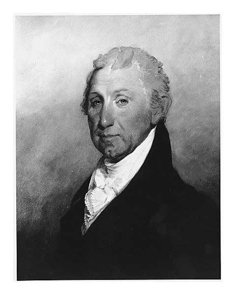
Image above: President James Monroe. Image right: Triumph, depicting eventual victory of Union, with reference to the Missouri Compromise. Created by Morris H. Traubel, 1861. Images courtesy Library of Congress.

Sponsor this page for $75 per year. Your banner or text ad can fill the space above.
Click here to Sponsor the page and how to reserve your ad.
-
Timeline
1823 Detail
April 25, 1823 - The War Department issues order for an expedition up the Red River and along the 49th parallel led by Stephen Long, which would mark the point of the official border between the United States and Canada.
Through the year of 1823, President Monroe seemed to be making a conscience effort to get issues such as borders, soveriegnty, and the affairs of the Americas in order prior to issuing the Monroe Doctrine later in the year.
For now, one task, issued through J.C. Calhoun, Secretary of the War Department, was to insure that both Canadian, British, and Americans understood where the boundary with Canada was, even if that was not the stated goal. So they hired Stephen Long, and sent him west from Philadelphia, up and down the Red River of the North, and back through the Great Lakes to Rochester, New York, to determine the 49th parallel and the upcoming establishment of it as the border. It took until 1842 for the section east of the Rockies to be passed by Congress in the Webster-Ashburton Treaty; until 1846 for the area west of the Rockies to be clarified.
But all that back and front story is but a small part of the adventure that Stephen Long took for the U.S. War Department on five expeditions covering twenty-six thousand miles. His expertise as a civil engineer and inventor added to, but eventually limited his short exploration career. But from the years 1817 to 1823, Long was an explorer of the American west akin to Zebulan Pike. But yes, the Red River and 49th parallel expedition to certify, at least per the American military, the Canadian border, would be his last.
The expedition was the idea of Lewis Cass, a Michigan politician, David B. Douglass, Henry Schoolcraft, a geographer, and Stephen Long himself. The expedition was primarily to be scientific in nature, with some military objectives that had not been disclosed to the general public. This concerned Canadian authorities and the British. If it were to establish a boundary, you'd had thought there would have been consultation. However, only a decade after the War of 1812, it was hard to have anything but suspicion between British and American politicians.
The expedition party left Philadelphia on April 30, 1923, and included Major Stephen Long, first in command, and twelve topographical engineers. The remainder of the expedition included astronomer James Edward Colhoun, zoologist Thomas Say, geologist William H. Keating, and landscape painter and designer Samuel Seymore. The party also included Italian adventurer Giacomo Beltrami, who left the exploration at Fort Garry after an argument with Long. Along the route they were to collecte information about the names and numbers of the Indian tribes; the Assiniboine, Dakota, Iroquois, Menominee, Ojibway, Osage, Ottawa, Potawatomi, Sauk, Winnebago, and Yanktonai.
Narrative of the Expedition, Excerpts, 1823
The success which attended the expedition to the Rocky Mountains, and the importantinformation which it imparted concerning the nature of the valley drained by the Missouriand its tributaries, of which nothing was known but what had been observed by Lewis and Clarke, induced the government of the United States to continue within its limits. Thefirst object which appeared to it deserving of was the district of country bounded by the Missouri, the Mississippi, and the Northern Boundary of the United States, ..."
"... The command of the expedition was intrusted to Major S. H. Long, and he received ordersfrom the War Department, dated April 25, 1823, of which the following is an extract: - "The route of the expedition will be as follows: - commencing at Philadelphia, thenceproceeding to Wheeling in Virginia, thence to Chicago via Fort Wayne, thence to Fort Armstrong or Dubuque's Lead Mines, thence up the Mississippi to Fort St. Anthony, thence to the source of the St. Peter's river, thence to the point of intersection between Red River and the forty-ninth degree of north latitude, thence along the northern boundary of theUnited States to Lake Superior, and thence homeward by the Lakes," Chapter One.
Wednesday, May 21st, the expedition left Columbus on its way to Piqua, situated on theMiami, about seventy miles west of Columbus, and likewise in the state The intermediate country is but thinly settled; the black, and not very deep, seldom more than it is underlaidwith sand and pebbles, which are evidently the detritus of granitic rocks, similar to thelarge boulders observed every where throughout the country. No rocks to be met within place. Although the country is very high, being probably from the best measurements which have been make, at least three hundred and fifty feet above the surface of Lake Erie, and consequently upwards of nine hundred feet above the surface of the ocean, itis very wet, being swampy, with occasional open woods and soft marshy prairies, very unlike those that are described by travellers as existing to the westward, and which we afterwards met with on the St. Peter's, &c," Chapter Two.
At Fort Wayne we made a stay of three days, during which our time was usefully and agreeably employed in acquiring some information concerning the manners andinstitutions of the Indian tribes which inhabit its vicinity. To a person visiting the Indiancountry for the first time, this place offered many characteristic and singular features. Thetown or village is small; it has grown under the shelter of the fort, and contains a mixedand apparently very worthless population. The inhabitants are chiefly of Canadian origin, all more or less imbued with Indian blood. Not being previously aware of the diversityin the character of the inhabitants, the sudden change from an American to a Frenchpopulation, has a surprising, and to say the least, an unpleasant effect; for the first twenty-four hours, the traveller fancies himself in a real Babel. The confusion of languages,owing to the diversity of Indian tribes which generally collect near a fort, is not removedby an intercourse with their half-savage interpreters: The business of a town of this kind differs so materially from that carried on in our cities, that it is almost impossible to fancy ourselves still within the same territorial limits; but the disgust which we entertain at thedegraded condition in which the white man, the descendant of the European, appears,is perhaps the strongest sensation which we experience, it absorbs all others. To seea being in whom, from his complexion and features, we should expect to find the same feelings which swell in the bosom of every refined man, throwing off his civilized habitsto assume the garb of a savage, has something which partakes of the ridiculous, as well as of the disgusting," Chapter Three.
Having engaged an Indian to lead us back from Mr. M'Coy's to the Chicago trace, weresumed our journey on the 3d of June. Our guide's hoary head would have satisfied evenHumboldt himself, that his assertion "that the hair of Indians never becomes gray," was too general. We have met with many instances, and the circumstance is so natural that weshould not have mentioned it, but for the importance attached to the slightest observationof a traveller so accurate as Humboldt generally is. After travelling about ten miles througha prairie we parted from our guide, who considered himself amply rewarded with about halfa pound of gunpowder. We then entered upon what is termed the fourteen mile prairie,which for the first seven miles presented an extensive plain uninterrupted by the least elevation, and undiversified by the prospect of a single tree. We had occasion to observe, on a former occasion, that the route which we travelled carried us along the height ofland that separates the waters tributary to the Mississippi from those which empty into the lakes; and we had an opportunity of seeing this confirmed, in this place, by the fact thata communication between those waters has been effected, during wet seasons, through the fourteen mile prairie. It appears that a very deep Swamp, which we avoided by ourvisit to the mission station, establishes a connection between two streams one of whichempties its waters into the Kankakee, while those of the other run to the St, Joseph. This has afforded, and still continues to afford every year an easy communication for canoes and small boats. An intercourse has likewise existed, in wet seasons,across the prairie east of the trader's establishment which we passed on the previous day. At noon we rested our horses in the vicinity of the remains of an Indian village, named the Grand Quoit, and we observed a few Indian lodges scattered along the edge of theforest which encloses this prairie. On discovering our party on the prairie, the tenants of the lodges immediately rode out of the woods, advanced towards us, and opened a conversation with our guides. Their intercourse with white men, and the consequent departure from their original customs, were observable in the circumstance of their commencing the conversation, and in their minute inquries respecting our object and intentions in visiting the country. They arc said to experience a great scarcity of food, which we can readily believe from the total absence of any kind of game which we have observed upon the route. An Indian who rode up near us, while we were partaking of our dinner, stopped and appeared to long after food; but called for none. We offered him some, which he very thankfully accepted, and seemed to eat with great voraciousness," Chapter Four.
The continuing chapters of the book describe in great detail the tribes that they met, the geology of the region, and the lakes and rivers that made up the journey home, as well as that 49th parallel. This being the last expedition of Major Stephen Long begs a small description of his exploits thereafter; he became involved with the American Philosophical Society, worked as an engineer for hire with various railroads, including the Baltimore and Ohio, and received patents for his locomotive designs. He was appointed to a position upon the formation of the newly separate U.S. Topographical Engineer Corps in 1838. During the Civil War, he was appointed a Colonel in the Union Army at the age of seventy-six.
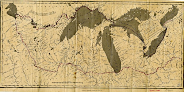
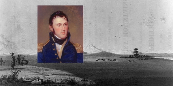
Image above: Map of the Stephen Harriman Long 1823 expedition up the Red River to determine the border with Canada, 49th parallel (route indicated in red), 1825, Engraver R. Penny, Publisher G.B. Whitaker. Courtesy Michigan State University via Wikipedia Commons. Image below: Montage (background) Illustration of Stephen Long expedition 1819-1820 into Rocky Mountains, 1823, Engraver John Heaviside Clark, Artist Samuel Seymore. Courtesy Library of Congress; (inset) Stephen Harriman Long, 1819, Charles Wilson Peale. Courtesy U.S. Department of the Interior via Wikipedia Commons. Source Info: "A History of the U.S. Topographical Engineers, 1818-1863," Henry P. Beers; archives.gov; "The Northern Expeditions of Stephen H. Long," Minnesota Historical Society; "Narrative of an expedition to the source of St. Peter's River, Lake Winnepeck, Lake of the Woods, &c. &c. performed in the year 1823, by order of the Hon. J.C. Calhoun, Secretary of War, under the command of Stephen H. Long, Major, U.S.T.E. Volume 1," 1824, compiled by William H. Keating from the notes of Major Long, Messrs. Say Keating, and J.C. Colhoun, Library of Congress; Wikipedia Commons.
History
Photo Bomb

The Smithsonian Institution rises above the Washington, D.C. landscape. Courtesy National Archives.
ABH Travel Tip
The bargains at the National Park Service continue, despite some recent increases in park fees. The National Park Pass is now called the America the Beautiful Pass, which admits all vehicle and family visitors for one year, and costs $80 for one twelve month period. The pass covers most Federal fee areas, including National Parks, Historic Sites, and National Forests. For those of 62 years of age or older, buy the America the Beautiful Senior Pass. For only $20 per year or $80 for a lifetime pass, you gain freeentrance for the rest of your life to all National Parks, National Historic Sites, and National Forests, and other federal fee sites for you, your spouse, and your children, plus discounts of 50% on some use fees, such as camping. Must be purchased in person at a National Fee location, which are the one hundred or so National Park Service sites that charge for entry.

President Andrew Jackson. Courtesy National Archives.
Official Souvenirs
America's Best History

Get history and national park souvenir t-shirts, mugs, stickers, posters, and other gifts from the official gear of America's Best History, now available on Zazzle, Cafepress, Amazon, and Redbubble.

Born this decade, Civil War General and eventual President
U.S. Grant begins his history here. Courtesy National Archives.
Timeline Book

The success which attended the expedition to the Rocky Mountains, and the importantinformation which it imparted concerning the nature of the valley drained by the Missouriand its tributaries, of which nothing was known but what had been observed by Lewis and Clarke, induced the government of the United States to continue within its limits. Thefirst object which appeared to it deserving of was the district of country bounded by the Missouri, the Mississippi, and the Northern Boundary of the United States, ..."
"... The command of the expedition was intrusted to Major S. H. Long, and he received ordersfrom the War Department, dated April 25, 1823, of which the following is an extract: - "The route of the expedition will be as follows: - commencing at Philadelphia, thenceproceeding to Wheeling in Virginia, thence to Chicago via Fort Wayne, thence to Fort Armstrong or Dubuque's Lead Mines, thence up the Mississippi to Fort St. Anthony, thence to the source of the St. Peter's river, thence to the point of intersection between Red River and the forty-ninth degree of north latitude, thence along the northern boundary of theUnited States to Lake Superior, and thence homeward by the Lakes," Chapter One.
Wednesday, May 21st, the expedition left Columbus on its way to Piqua, situated on theMiami, about seventy miles west of Columbus, and likewise in the state The intermediate country is but thinly settled; the black, and not very deep, seldom more than it is underlaidwith sand and pebbles, which are evidently the detritus of granitic rocks, similar to thelarge boulders observed every where throughout the country. No rocks to be met within place. Although the country is very high, being probably from the best measurements which have been make, at least three hundred and fifty feet above the surface of Lake Erie, and consequently upwards of nine hundred feet above the surface of the ocean, itis very wet, being swampy, with occasional open woods and soft marshy prairies, very unlike those that are described by travellers as existing to the westward, and which we afterwards met with on the St. Peter's, &c," Chapter Two.
At Fort Wayne we made a stay of three days, during which our time was usefully and agreeably employed in acquiring some information concerning the manners andinstitutions of the Indian tribes which inhabit its vicinity. To a person visiting the Indiancountry for the first time, this place offered many characteristic and singular features. Thetown or village is small; it has grown under the shelter of the fort, and contains a mixedand apparently very worthless population. The inhabitants are chiefly of Canadian origin, all more or less imbued with Indian blood. Not being previously aware of the diversityin the character of the inhabitants, the sudden change from an American to a Frenchpopulation, has a surprising, and to say the least, an unpleasant effect; for the first twenty-four hours, the traveller fancies himself in a real Babel. The confusion of languages,owing to the diversity of Indian tribes which generally collect near a fort, is not removedby an intercourse with their half-savage interpreters: The business of a town of this kind differs so materially from that carried on in our cities, that it is almost impossible to fancy ourselves still within the same territorial limits; but the disgust which we entertain at thedegraded condition in which the white man, the descendant of the European, appears,is perhaps the strongest sensation which we experience, it absorbs all others. To seea being in whom, from his complexion and features, we should expect to find the same feelings which swell in the bosom of every refined man, throwing off his civilized habitsto assume the garb of a savage, has something which partakes of the ridiculous, as well as of the disgusting," Chapter Three.
Having engaged an Indian to lead us back from Mr. M'Coy's to the Chicago trace, weresumed our journey on the 3d of June. Our guide's hoary head would have satisfied evenHumboldt himself, that his assertion "that the hair of Indians never becomes gray," was too general. We have met with many instances, and the circumstance is so natural that weshould not have mentioned it, but for the importance attached to the slightest observationof a traveller so accurate as Humboldt generally is. After travelling about ten miles througha prairie we parted from our guide, who considered himself amply rewarded with about halfa pound of gunpowder. We then entered upon what is termed the fourteen mile prairie,which for the first seven miles presented an extensive plain uninterrupted by the least elevation, and undiversified by the prospect of a single tree. We had occasion to observe, on a former occasion, that the route which we travelled carried us along the height ofland that separates the waters tributary to the Mississippi from those which empty into the lakes; and we had an opportunity of seeing this confirmed, in this place, by the fact thata communication between those waters has been effected, during wet seasons, through the fourteen mile prairie. It appears that a very deep Swamp, which we avoided by ourvisit to the mission station, establishes a connection between two streams one of whichempties its waters into the Kankakee, while those of the other run to the St, Joseph. This has afforded, and still continues to afford every year an easy communication for canoes and small boats. An intercourse has likewise existed, in wet seasons,across the prairie east of the trader's establishment which we passed on the previous day. At noon we rested our horses in the vicinity of the remains of an Indian village, named the Grand Quoit, and we observed a few Indian lodges scattered along the edge of theforest which encloses this prairie. On discovering our party on the prairie, the tenants of the lodges immediately rode out of the woods, advanced towards us, and opened a conversation with our guides. Their intercourse with white men, and the consequent departure from their original customs, were observable in the circumstance of their commencing the conversation, and in their minute inquries respecting our object and intentions in visiting the country. They arc said to experience a great scarcity of food, which we can readily believe from the total absence of any kind of game which we have observed upon the route. An Indian who rode up near us, while we were partaking of our dinner, stopped and appeared to long after food; but called for none. We offered him some, which he very thankfully accepted, and seemed to eat with great voraciousness," Chapter Four.
The continuing chapters of the book describe in great detail the tribes that they met, the geology of the region, and the lakes and rivers that made up the journey home, as well as that 49th parallel. This being the last expedition of Major Stephen Long begs a small description of his exploits thereafter; he became involved with the American Philosophical Society, worked as an engineer for hire with various railroads, including the Baltimore and Ohio, and received patents for his locomotive designs. He was appointed to a position upon the formation of the newly separate U.S. Topographical Engineer Corps in 1838. During the Civil War, he was appointed a Colonel in the Union Army at the age of seventy-six.
Image above: Map of the Stephen Harriman Long 1823 expedition up the Red River to determine the border with Canada, 49th parallel (route indicated in red), 1825, Engraver R. Penny, Publisher G.B. Whitaker. Courtesy Michigan State University via Wikipedia Commons. Image below: Montage (background) Illustration of Stephen Long expedition 1819-1820 into Rocky Mountains, 1823, Engraver John Heaviside Clark, Artist Samuel Seymore. Courtesy Library of Congress; (inset) Stephen Harriman Long, 1819, Charles Wilson Peale. Courtesy U.S. Department of the Interior via Wikipedia Commons. Source Info: "A History of the U.S. Topographical Engineers, 1818-1863," Henry P. Beers; archives.gov; "The Northern Expeditions of Stephen H. Long," Minnesota Historical Society; "Narrative of an expedition to the source of St. Peter's River, Lake Winnepeck, Lake of the Woods, &c. &c. performed in the year 1823, by order of the Hon. J.C. Calhoun, Secretary of War, under the command of Stephen H. Long, Major, U.S.T.E. Volume 1," 1824, compiled by William H. Keating from the notes of Major Long, Messrs. Say Keating, and J.C. Colhoun, Library of Congress; Wikipedia Commons.
History
Photo Bomb
The Smithsonian Institution rises above the Washington, D.C. landscape. Courtesy National Archives.
ABH Travel Tip
The bargains at the National Park Service continue, despite some recent increases in park fees. The National Park Pass is now called the America the Beautiful Pass, which admits all vehicle and family visitors for one year, and costs $80 for one twelve month period. The pass covers most Federal fee areas, including National Parks, Historic Sites, and National Forests. For those of 62 years of age or older, buy the America the Beautiful Senior Pass. For only $20 per year or $80 for a lifetime pass, you gain freeentrance for the rest of your life to all National Parks, National Historic Sites, and National Forests, and other federal fee sites for you, your spouse, and your children, plus discounts of 50% on some use fees, such as camping. Must be purchased in person at a National Fee location, which are the one hundred or so National Park Service sites that charge for entry.
President Andrew Jackson. Courtesy National Archives.
Official Souvenirs
America's Best History
Get history and national park souvenir t-shirts, mugs, stickers, posters, and other gifts from the official gear of America's Best History, now available on Zazzle, Cafepress, Amazon, and Redbubble.
Born this decade, Civil War General and eventual President
U.S. Grant begins his history here. Courtesy National Archives.
Timeline Book
History Photo Bomb
The Smithsonian Institution rises above the Washington, D.C. landscape. Courtesy National Archives.
ABH Travel Tip
The bargains at the National Park Service continue, despite some recent increases in park fees. The National Park Pass is now called the America the Beautiful Pass, which admits all vehicle and family visitors for one year, and costs $80 for one twelve month period. The pass covers most Federal fee areas, including National Parks, Historic Sites, and National Forests. For those of 62 years of age or older, buy the America the Beautiful Senior Pass. For only $20 per year or $80 for a lifetime pass, you gain freeentrance for the rest of your life to all National Parks, National Historic Sites, and National Forests, and other federal fee sites for you, your spouse, and your children, plus discounts of 50% on some use fees, such as camping. Must be purchased in person at a National Fee location, which are the one hundred or so National Park Service sites that charge for entry.
President Andrew Jackson. Courtesy National Archives.
Official Souvenirs
America's Best History
Get history and national park souvenir t-shirts, mugs, stickers, posters, and other gifts from the official gear of America's Best History, now available on Zazzle, Cafepress, Amazon, and Redbubble.
Born this decade, Civil War General and eventual President U.S. Grant begins his history here. Courtesy National Archives.
Timeline Book