-
Timeline - 2010s
Healthcare reform, a slow economic increase, and an enemy that refuses to go away dominate the first years of the decade as America struggles to find its footing from the economic collapse of 2008 and the international troubles of terrorism and the mideast.
More 2000s

Franklin Delano Roosevelt Memorial, Washington, D.C.
Click here to Sponsor the page and how to reserve your ad.
-
Timeline
Detail - 2017
August 25, 2017 - Disastrous hurricane season in the Gulf of Mexico, Caribbean, and Atlantic seaboard begins with Hurricane Harvey hitting the Houston area, causing $125 billion in damage. It is followed on September 6 with Hurricane Irma, the strongest Atlantic hurricane in history striking Florida, and on September 19, Hurricane Maria strikes Puerto Rico. Those two hurricanes cause over $150 billion in additional damages.
Who would have thought that when the weather season of hurricanes would come in 2017, that three would pop across the Atlantic Ocean, then roar through the Caribbean, hit the southeast with landfalls in Texas, Florida, and Puerto Rico, all within the space of one month. Of the ten named hurricanes within the North Atlantic that year, six would be major, three would be in a damn row. On August 25, Hurricane Harvey hit, wind speeds up to 115 MPH. Impacted thirteen million people; loss of power alone in southeast Texas reached two hundred and fifty thousand humans. On September 6, the next one, Irma, crashed into Florida. Winds up to 155 MPH. Some experts say this was the largest Atlantic storm they had ever seen. Finally, the third, Hurricane Maria, devastated Puerto Rico, with wind speeds at 150 MPH. Approximately five hundred people were killed. The complexity and bunching in time of these events stressed first responders, aid relief agencies, and the people in the hardest hit areas all across the Caribbean and southeast United States. And the horror of those lost still resonates across the region.
This year was the first in twelve that the United States had seen a Major hurricane of Category Three or Higher (Wilma in 2005). Organizations such as Americares provided seventy-five million dollars worth of support over three hundred and fifty-seven shipments, filled an estimated seven hundred and forty-three thousand prescriptions, and rebuilt twelve health facilities in Dominica alone.
Hurricane Harvey
Off the coast of West Africa on August 12, the large weather mass diminished after one day, but gained strength three days later. A tropical depression would form four hundred and forty-four miles east of Barbados by August 17; twelve hours later it was a tropical storm. It moved quickly, passing off the islands of Barbados and St. Vincent on August 18. As it weakened over the next several days, Harvey was not thought to grow as extensively as it did, moving into the Bay of Compeche, where its convection began to rise. However, it was poorly organized. By August 24, an eye had formed, and Harvey was becoming a huge problem.
Harvey would make landfall along the Middle Texas coast in Rockport, a Category 4 Storm. It had plied its way along the Lesser Antilles and weakened in the central Caribbean. However, once it reformed, the hurricane stalled over the central coast; Port Aransas, Matagorda, Copano Bay, Padre Island National Seashore. Highest level storm gage showed 6.7 feet above normal at Port Lavaca. Other readings would show higher; the estimation of the highest inundation was eight to ten feet above ground level.
Sixty-five to seventy inches of rain would fall, mostly due to its duration of seven days over land, a whopping one hundred and seventeen hours. Flooding reached unthought of proportions. The damage was extensive. Predominantly the loss of sixty-eight lives (thirty-six of them in Harris County near Houston) was the harshest crush, but its cost would include the second most expensive hurricane in history, adjusted for inflation. Only Katrina in 2005 would remain above it. And Hurricane Harvey was not confined to Texas; rainfall at Vinton, Louisiana would reach twenty-four inches. Even Tennessee locations reported ten inches of rain. There were sixty-two tornadoes spawned.
Three hundred thousand structures were flooded. Five hundred thousands cars inundated. Forty thousand people were displaced. Thirty thousand water rescues were conducted by first responders.
History Video - The Devastating Month of Hurricanes 2017
Watch this account of the three hurricanes which attacked the Caribbean to the continental United States over one month in the hurricane season of 2017. With photos, video, music, and narration, see the NOAA preparations and rescue efforts, plus the damage that it caused.
Hurricane Irma
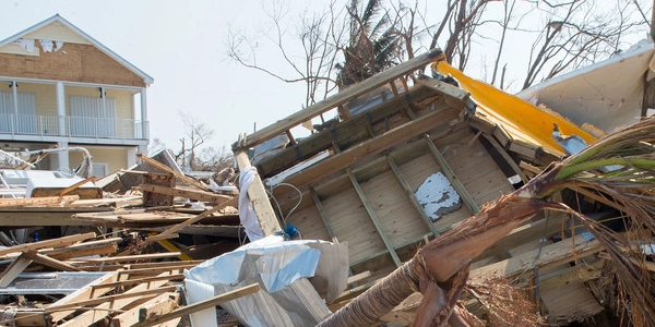
There was nothing shy about Hurricane Irma as it strenghthened to a rare Category Five hurricane. It made a prolific number of landfalls, seven total, four at its Cat 5 strength in the north islands of the Caribbean. By the time it reached the Florida Keys, it had diminished slightly to Category Four; later in southwestern Florida, its intensity level dropped to Category Three.
No matter the number, this Atlantic Basin hurricane would cause devastating destruction after it formed off the coast of Africa on August 27, 2017. Three days later, it was designated a tropical depression one hundred and twenty miles west-southwest of the Cabo Verde Islands. Less than thirty hours later, it was already a hurricane forming a ragged eye with a small diameter, fifteen miles.
As Irma approached the Leeward Islands on September 4, the eye of the storm had grown in size. The next day, it reached its maximum intensity seventy miles east of Barbuda. First landfall, now a Category Five, occurred on September 6 in Barbuda, where ninety-five percent of its structures were damaged or destroyed, then St. Martin, then the British Virgin Islands (Tortola and Ginger Island). By September 8, it had passed the Turks and Caicos Islands and landed in the Bahamas. Its fifth landfall occurred on September 9 at Cayo Romano, Cuba. It was the next day when a slightly weaker Irma whooshed over the Florida Straights as a Category Four in the Gulf of Mexico and its sixth landfall near Cudjoe Key.
The final landfall occurred at Marco Island, Florida on September 10. Although it was weaker, its wind field had grown tremendously, now reaching up to three hundred and sixty miles from its center. One unique fact; due to the northeast winds, Tampa Bay emptied instead of flooding. Three to six feet of water were gone, stranding manatees in the mud. Irma continued into Georgia and South Carolina, now a tropical storm.
Rainfall was not as intensive as Hurricane Harvey, but still caused flooding. In Puerto Rico there were totals of ten to fifteen inches. Topes De Collantes in Cuba reported twenty-four inches; the River Zaza had record flooding. In Florida, the maximum rainfall was reported near Ft. Pierce with nearly twenty-two inches. Record flooding of the St. John's River, as well as within the Metropolitan Area of Jacksonville, required several hundred rescues. Some streets rose to five feet in depth. There were twenty-five tornadoes spread about the hurricane. The storm kept its maximum intensity for thirty-seven hours. Across the Caribbean and United States, death totals rose to forty-six.

Hurricane Maria
The third hurricane, Maria, formed and moved across the Atlantic Ocean from September 10 to September 17, 2017. Seven hundred miles east-southeast of the Lesser Antilles on September 16, it had formed into a tropical depression. Three hours later it was a tropical storm. One day more and it was intensified to hurricane status, Category One, with a sustained seventy-five miles per hour wind speed.
The intensification became critical over the next day, rising to a dangerous Category Five storm with the assistance of warm water. She made landfall in Dominica of the Windward Islands, then raced toward the U.S. Virgin Islands and Puerto Rico with the same category. On September 20, the eye wall moved over St. Croix; it had reached winds of 175 MPH, but then lowered to 155 MPH as it struck mainland Puerto Rico. Its pressure of 908 hPa made it the tenth most intense Atlantic hurricane to date.
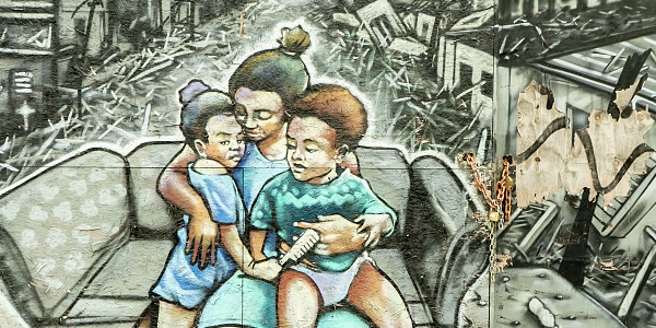
Flash flooding overwhelmed the streams and hillsides of northern Puerto Rico. Residents had not yet recovered from Hurricane Irma ramming into the island; two-thirds were without electricity still, as well as one-third without clean water. When it hit as a Category Four and Five, the FAA and National Weather Service radar was destroyed; it was supposed to handle 133 MPH winds. Trees were uprooted, the remaining were naked. Ninety-five percent of cell towers were damaged, leaving residents without service, and the Irma damaged electrical grid was now completely powerless.
Fifteen to twenty inches of rain fell on the island, raising thirty rivers above flood stage. One month later, ninety-two percent of roads were not open. Damage would reach an estimated ninety billion in Puerto Rico and the Virgin Islands.
Photo above: Damage from Hurricane Irma in Big Pine Key, Florida, 2017, J.T. Blatty/FEMA. Courtesy Wikipedia Commons. Photo below: Edited version of the photograph of "We will rise" mural celebrating Puerto Rico after the 2017 Hurricane Maria, 2020, Camilo Vagara. Courtesy Library of Congress. Info source: "Hurricane Harvey, August 17 to September 1, 2017," 2018, Eric S. Blake and David Zelensky, National Hurricane Center, Tropical Report; "Hurricane Irma, 30 August to 12 September 2017," 2026, John P. Cangialosi, Andrew S. Latto, and Robbie Berg, National Hurricane Center; "Major Hurricane Maria - September 20, 2017," National Weather Service; "Hurricane Maria's devastation of Puerto Rico," 2018, Michon Scott, Climate.gov; "2017 Atlantic Hurricane Season," NOAA; "Eight Hurricanes that Struck the US in 2017," worldatlas.com; "Responding to Three Hurricanes in 2017," 2018, americares.org; "2017 Atlantic Hurricane Season Recap: 17 Moments We'll Never Forget," 2018, Jonathan Belles, weather.com; Wikipedia Commons.
History Photo Bomb

President Barack Obama. Courtesy Wikipedia Commons.
Official Souvenirs
America's Best History


The Statue of Liberty was closed due to Hurricane Sandy until July of the next year; Ellis Island remained closed until 2014.
Buy Chronology

Timeline History

Want a copy of the Timeline. Now available in easy to search digital format for your Kindle, Nook, or pdf format. Also comes in paperback, too.
ABH Travel Tip

Much of America's best history takes in the beauty and nature of our national parks, plus our seashores and preserves. From the first park in Yellowstone, from the coast of Maine to the tropical reaches of the Everglades and the Big Cypress Preserve, photo above, next door. Check out the history of the USA as made by our land.