-
Missouri National Recreational River
Nebraska and South Dakota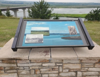
Wayside exhibit overlooking the Missouri National Recreational River from the Nebraska side, 2024. Courtesy America's Best History.
Associate Pages
Lewis and Clark
Expedition

Photo above: Canoers on the banks of the Missouri River. Courtesy National Park Service. Right: Huge metal sculpture of Sacagawea overlooking the Missouri River at the Nebraska Visitor Center, 2024. Courtesy America's Best History.

Missouri National Recreational River
The entire Missouri River runs 2,341 miles from the Centennial Mountains to a connection to the Mississippi River just north of St. Louis, Missouri. In the center of that is a one hundred mile stretch, bordering Nebraska and South Dakota that now makes up the National River known as the Missouri National Recreational River. Yes, this is the river that Lewis and Clark took west on their expedition to map the Louisiana Purchase lands just bought during the Thomas Jefferson administration. Yes, it was made even more famous by the guide Sacagawea, of the Shoshoni, who shepherded the men and their crew of the arduous journey. But while a vacation to the park has its history rooted in the Indian nations that lived in the territory for hundreds, if not thousands, of years, today while paying homage to that, it now provides a recreation experience in various parks, landings, fishing holes, hiking trails, and boat ramps. Whichever you prefer, or a combination of both, a weekend in one of the many campgrounds sounds like good history and fun couple of days.
Click here to Sponsor the page and how to reserve your ad.

Missouri National Recreational River Then
For twelve thousand years, the indigenous people of the plains had used a nomadic lifestyle surrounding the Missouri River and the large buffalo herds that roamed the prairies and mountains around it. Along its entire route, the major tribes included the Otoe, Missouria, Omaha, Ponca, Brulé, Lakota, Arikara, Hidatsa, Mandan, Assiniboine, Gros Ventres, and Blackfeet. In Yankton, the Yankton Sioux tribe known as Ihaƞktoƞwaƞ Dakota Oyate were located; albeit controlling a small area of the river and countryside. Also part of the territory of the Missouri National Recreational River were the Ponca. Surrounding much of the area were also the Crow Creek. On the Nebraska side of the river in the area were also the Ponca, as well as the Yankton Sioux.
Once France sold the lands along the Missouri River to the United States in the Louisiana Purchase, for 3 cemts per acre, total $15 million, an exploration of the territory would have to take place. The best known, the Lewis and Clark Expedition, included thirty-three men in three boats. They were to find a passage, hopefully by river, from the known Missouri River to the known Columbia River in Oregon. It would take two years and the assistance of a Lemhi Shoshone woman known as Sacagawea, a teenager.
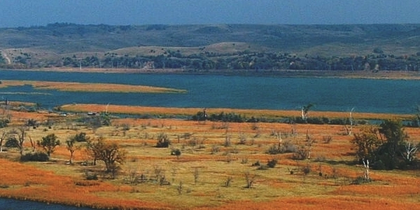
Photo above: Lewis and Clark reach a Shoshone Camp led by Sacagawea, 1918, Charles Marion Russell. Courtesy Gilcrest Museum via Wikipedia Commons. Camp would have been outside the Missouri National Recreational River area, however it shows the approach that Sacagawea and Lewis and Clark made with the tribes along the way. Below: Beautiful fall scene from a distance of the Missouri River. Courtesy National Park Service.
Missouri National Recreational River Now
Today, the National River is divided into two sections; the first, begun in 1978, 59 miles between Gavins Point Dam and Ponca State Park. The second, in 1991, added a 39 mile section from Fort Randall Dam and Niobrara, Nebraska. The stretch of river in the park is the only undammed and unchanneled section south of Montana. There are recreation parks along the one hundred miles, including state parks Ponca and Niobrara, plus U.S. Army Corps of Engineer sites. You can camp, fish, hike, boat all along the river, and learn the history of the area, both natural and Lewis and Clark historic, at many of the Visitor Centers.
And if the water is low, there's even a shipwreck here, the steamer North Alabama. But don't think they were the only boats that had problems with the changing currents of the Missouri. Over three hundred ships were wrecked in its currents from 1819 to 1920.
Minute Walk in History
Get a view of one hundred miles of the middle Missouri River where for twelve thousands years native American tribes such as the Punca and Yankton Sioux led their nomadic life amongst the buffalo that provided for them. It is also the river where history was made, albeit European style, when President Jefferson made the Louisiana Purchase and sent Lewis and Clark on their expedition, with great help by Shoshoni guide Sacagawea.
T-Shirts and Souvenirs

For those who love the history of Lewis and Clark and Sacagawea plus the recreation that now awaits along this one hundred mile stretch of river, check out Missouri National Recreational River t-shirts, sweatshirts, mugs, stickers, and other souvenirs.
Missouri National Recreational River
Things You Should Not Miss
1. For an overview of what's here, go to the Visitor Center in downtown Yankton, South Dakota. It also serves as park headquarters, but beside the park ranger orientation and a film, it's a great place to get your bearings on where you can do what.
2. The metal statue of Sacagawea overlooking the Missouri River from the Nebraska bluff where it's Visitor Center sits is not only an art masterpiece, but indicates what all of us now know. Lewis and Clark would not have made it without her. Below the Visitor Center nearer the bridge is a parking lot with waysides. Great place for pictures and views.
3. Try to spend a night at Ponca State Park, either in one of their beautiful cabins overlooking the water, or in one of their three campgrounds.
4. If you are able and its one of your pleasures, canoe or kayak the river just as Lewis and Clark did two hundred years ago.
Visitor FAQ
What's There Now
There are a variety of Visitor Centers at different points of the park. Park headquarters and the main Visitor Center, as noted above, are located in downtown Yankton, South Dakota. It is open on weekdays only from 8 a.m. to 4:30 p.m. Exhibits, orientation, a film "River of Change" eighteen minutes long, and facilities are located there. The address is 508 East 2nd Street, Yankton, South Dakota. 57078.
The Missouri National Recreational River Resource and Education Center is located in Ponca State Park, which is to the east of Yankton in the 59 mile section of the park, but on the Nebraska side of the river. Ponca State Park is a must if you are coming from the east. It has a great Visitor Center, 31 cabins to rent, camping at three campgrounds, most available on a First Come, First Served basis. Hooray! Some can be reserved. The campgrounds are named Turkey Ridge, Oak Bluff, and Riverfront. There is a $14 fee to enter the park, and cabins or camping is extra.
Niobrara State Park is on the western end of the Missouri National Recreational River national park site, actually a National Scenic River on its own to the west. The State Park includes a small visitor center, cabins, and camping options.
The Lewis and Clark Visitor Center is run by the U.S. Army Corp of Engineers at Gavins Point Dam. Yes, there is a lake, but also opportunities to camp, fish, swim, and do a whole lot more. Two million people visit the dam and park per year. There is also a fish hatchery and aquarium at Gavins Point.
Fort Randall Dam and Lake Francis Case draw one million people per year to its recreation activities. Campgrounds are available here as well. It is also run by the U.S. Army Corp of Engineers. No info on whether you have to rise early or salute.
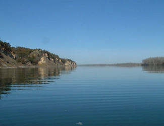
Photo above: A wide stretch of the Missouri River with the bluffs of Nebraska and South Dakota on each side. Courtesy National Park Service.
Park Activities
Enjoy the wildlife, including Prairie Dogs, one of which made it all the way back to Washington after a capture by the Lewis and Clark Expedition. There is a wide variety of birding opportunities. Hiking and biking trails can be found all over the place, but if you prefer to drive your viewing pleasure will be well worth it at many viewpoints along the Missouri River. If you like to get wet, there's many ways to do that; one great way is to canoe or kayak the river. There are many boat ramps along both banks. And there are kayaking guided tours as well. There are specific location where hunting is allowed.
If you like a more sedate adventure, Park Rangers provide historic and nature programs from the various Visitor Centers. Check the calendar for what is available.
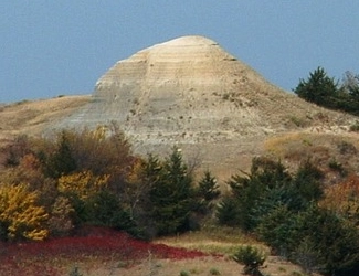
Photo above: Near this hill outside Lynch, Nebraska, men of the Lewis and Clark Expedition captured a prairie dog and later sent it back to President Jefferson, date unknown. Courtesy National Park Service.

Lewis and Clark Expedition
One year before, President Thomas Jefferson had doubled the size of the United States with his purchase of the Louisiana Purchase on April 30, 1803, thus creating a nation that was truly sea to shining sea. But just what had he bought? It was wild Indian territory that had been explored by trappers and some explorers, yet not truly mapped in a way that would allow for western expansion and commerce of a broad kind. Well, that's where Captain Meriwether Lewis and William Clark came in. They would traverse the Missouri River first, prior to climbing the Rocky Mountains and ending in Oregon.
Along the way, the met their Indian guides, Sacagawea, and others who made it possible to pass through territories controlled by tribes, not only her own Shoshone. And beyond a journey west to map what President Thomas Jefferson had bought, they had to make it back. Although we know this truth today, both men and their guide made it back safely.
Photo above: Engraving of Meriwether Lewis, 1805, Saint-Memin, Charles Balthazar, Julien Fevret de. Courtesy Library of Congress. Below: Engraving of William Clark, 1807, Saint-Memin, Charles Balthazar, Julien Fevret de. Courtesy Library of Congress.


Missouri National Recreation River Links
Missouri National Recreational River
Niobrara National Scenic River
Visit Yankton, SD