Click here to Sponsor the page and how to reserve your ad.
-
Timeline
1811 - Detail
December 16, 1811 - An earthquake near New Madrid, in the Mississippi Valley, reverses the course of the Mississippi River for a period of time. This quake was the first of two major earthquakes which preceded the largest quake ever in the United States two months later.

It was 2:15 a.m. on December 16, 1811 when the citizens of the area around New Madrid, Missouri felt a large shake of the ground. Some, plying their trade on the Mississippi River and surrounding waterways saw the waters shift, and heard the roar above the sounds of nature. And as striking as this sound and shake were, what was to come would be even stronger. Amidst the thousands of shakes that would occur over the next month and more, there would be five significant earthquakes, including this one on December 16. One, that of February 11, 1812, would be the largest quake in the recorded history of the United States east of the Rocky Mountains. By the end of this seismic activity, an estimated nearly two thousand aftershocks above M3.0 and seven major quakes above 6.0, the odd occurrences around New Madrid would be astonishing. Half of the town would be destroyed. The Mississippi River would flow backwards (that may have been an illusion) for a time. The Reelfoot River would cease to flow into it, but a new lake from its source, the Reelfoot Lake, would be created.
But how did the first one strike and what would be its impact? It is estimated that the first December 16 quake would register at 7.5 magnitude on the Richter scale. It shook with a ferocity, in some measurements, greater than that of the 1964 Alaska earthquake and the 1906 San Francisco earthquake, even though their magnitudes may have been higher. It was centered in northeast Arkansas, just below New Madrid, near today's Blytheville, Arkansas. Ground liquification up to ten feet high rose into the air near the epicenter. And the first major shock of this seismic activity along the New Madrid seismic region was not the final shock of that day. Five hours later, at 7:15 a.m., a second earthquake, which some refer to as an aftershock and others as one of the principal earthquakes of this four month activity, occurred north of the first in Missouri. It is estimated to register at 7.0. There would be three additional large aftershocks on December 16 and 17. They registered in size from M6.0 to M6.5. In total, the aftershocks of the next two days that registered above M5.5 totaled six.
The first shock only caused minor damage to buildings, however, the area of significant and damaging ground motion (Modified Mercalli Intensity greater than or equal to VII) was estimated at 600,000 square kilometers. Trees were bent, landslides caused, and waves rose on the Mississippi River high enough to topple boats. Little Prairie, Arkansas, a town of about one hundred people, sank into the Mississippi River, albeit slowly. Nobody was hurt. Little Prairie, Missouri, located on the site of the former Fort San Fernando, was also destroyed after the initial shock and aftershocks. The residents left town through the waters, heading west until finding high ground eight miles out. When they reached New Madrid on December 24, it had been abandoned. The one thousand residents of New Madrid had left town for a campsite several miles west. Estimates of the casualties range according to source. Some state that only one person died; others contend it was nine.
Could others in the United States beyond this predominantly isolated region feel the shock? Yes. The shake could be felt in New York City and Washington, D.C. It woke President James Madison in the White House. Church bells rang in Charleston. Chimneys fell in Cincinnati. Primary shaking, from one to three minutes, was felt in an area that seemed to reach Nashville and Louisville.
Eye Witness Accounts
William Pierce, boatman south of New Madrid on the Mississippi River. "The earth, river, etc., torn with furious convulsions, opened in huge trenches. There through a thousand vents sulphorous streams gushed from its very bowels leaving vast and almost unfathomable caverns."
Eliza Bryan, eyewitness. "On the 16th of December, 1811, about two o'clock, a.m., we were visited by a violent shock of an earthquake, accompanied by a very awful noise resembling loud but distant thunder, but more hoarse and vibrating, which was followed in a few minutes by the complete saturation of the atmosphere, with sulphurious vapor, causing total darkness. The screams of the affrightened inhabitants running to and fro, not knowing where to go, or what to do - the cries of the fouls and beasts of every species - the cracking of trees falling, and the roaring of the Mississippi - the current of which was retrograde for a few minutes, owing as is supposed, to an irruption in its bed - formed the scene truly horrible."
Resident of the Pemiscot Bayou. "Blew up for a distance of nearly fifty miles."
John Bradbury, English botanist and boatman on a small island south of New Madrid after the first aftershock. "Terrible, but not equal to the first."

The New Madrid Seismic Zone
The New Madric seismic zone includes the area of northeast Arkansas, southwest Missouri, eastern Kentucky, and eastern Tennessee along the Mississippi embayment, and remains today as the most active zone for underground activity in the eastern half of the United States. Since seismic records have been recorded, in 1974, thousands of small to moderate earthquakes have been recorded along the rifts of the zone, including the Reelfoot rift which dates back five hundred million years. It is estimated that two hundred small quakes occur each year. Sand blows caused by the liquification process still occur, some caused by the 1811-1812 quakes with others attributed to quakes from prehistoric times.
The geologic record of this zone suggests that over the past four thousand five hundred years, there may have been a sequence of major earthquakes with several registering between M7.0 and M8.0. The United States Geological Service (USGS) estimates that there is a seven to ten percent chance that a major earthquake measuring near the 1811-12 New Madrid quakes will occur over the next fifty years. There is a twenty-five to forty percent chance of a level M6.0 or greater quake occuring over the same period of time.
The estimations above are taken from the USGS; other estimations list the earthquakes somewhat higher on the scale, some reaching above 8.0.
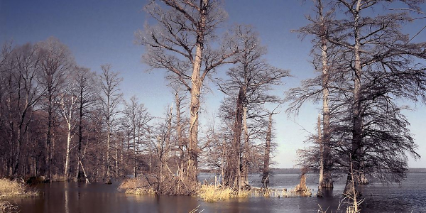
Image above: Montage of (left) drawing of the New Madrid Earthquake, circa 1851, book by Henry Howe. Courtesy Wikipedia Commons; (right) landslide trench and ridge from New Madrid earthquakes, Chickasaw bluffs, 1969. Courtesy USGS. Image below: Reelfoot Lake, Copyright 2001, Jeremy Atherton. Courtesy Wikipedia Commons CC2.5. Source Info: "1811-1812 New Madrid Earthquakes Overview," 1974, Otto W. Nuttli, USGS; "Science of the New Madrid Seismic Zone," USGS; USGS; "The Great Midwest Earthquake of 1811," 2011, Elizabeth Rusch, Smithsonian Magazine; "The Earthquake That Never Went Away," Dr. David Stewart and Dr. Ray Knox; "The New Madrid Earthquakes of 1811-12," 2018, Ron Soodalter; Missouri Life Magazine; new-madrid.mo.us; "The End of the World, New Madrid Earthquakes of 1811-1812," Garry Glen Jones; Library of Congress; Wikipedia Commons.
History Photo Bomb

Sunset at the mouth of the Columbia River, near Astoria,
Oregon. Courtesy National Archives.
Timeline Book

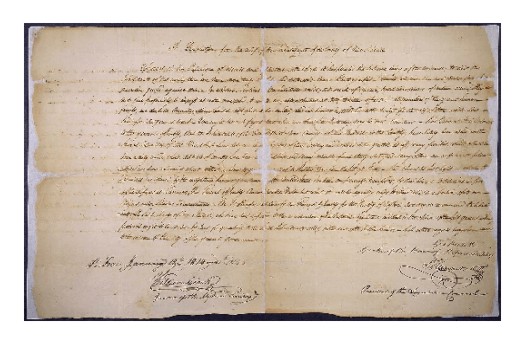
Resolution for federal aid from the Missouri Territory during
the time of the New Madrid earthquakes in 1811-12. Courtesy National Archives.
ABH Travel Tip
The National Park Service has, over the past several years,
announced increases in the entrance fees to several of the most visited National Parks. For a list of those fees, please visit National Park Service and
check for the park of your interest. A national park vacation is one of the most economical in the nation, but they are subject to the same inflationary pressures of theme parks and other attractions. We, at americasbesthistory.com are urging, however, that the park service keep these increases at a minimum, so that america's best classrooms remain open to all who seek to witness their history and beauty.

Capture of the Sloop of War Frolic by the U.S. Sloops of War
Wasp, October 18, 1812. Print by F. Kearny from sketch by Lt. Claxton. Courtesy National Archives.