Sponsor this page. Your banner or text ad can fill the space above.
Click here to Sponsor the page and how to reserve your ad.
-
Timeline
1838 - Detail
June 12, 1838 - The Territory of Iowa is organized.
It had been part of the Louisiana Purchase purchased by the United States in 1803 from France, but for the first three decades of its existence within the confines of the USA, had been bantied about in other territories. At first, it was governed by the Territory of Indiana as part of the District of Louisiana, but that only lasted for two years as new settlers in the lands of Iowa and other west of the Mississippi territory, of which there were few, wanted to own slaves, which Indiana did not allow. In 1805, all lands of the Louisiana Purchase north of 33 latitude became part of the Territory of Louisiana. In 1812, the southern portion of that territory became the state of Louisiana, again moving Iowa into the newly created Missouri Territory for nine years. When Missouri was made a state on March 2, 1821, Iowa was shuttled off to the status of an unorganized territory with few colonists and without most of the vestiges of government.
On June 28, 1834, the Territory of Michigan took it in, as well as what would be today's Wisconsin, Minnesota, and part of the Dakotas. Fort Des Moines was built on the Mississippi River, stationed by three companies of dragoons, although not at today's location of the city. The status as part of Michigan only lasted for two years. Michigan also wanted to become, and did, a state that year, 1836, forcing the two districts that had been established as part of Michigan, Dubuque and Des Moines counties, into the Territory of Wisconson as the Iowa District. By 1838, the white settlers of Iowa, which had only been officially allowed since the end of the Black Hawk War in 1832 (prior to June 1, 1833 when official white settlement began there was only an estimated 40-50 white settlers in the territory), wanted a territory of their own. Most of the Indian tribes had been moved fifty miles west of the Mississippi River after the war, in a treaty known as the Black Hawk Purchase. A census had been taken on September 9, 1836; there were now 10,531 white settlers in the two Iowa districts.
During its years with the Territory of Wisconsin, discussions began to separate the lands of Iowa, those west of the Mississippi River, from Wisconsin. A convention held in Burlington on November 1, 1837 sent a petition to Washington for organization. However, politicians in Washington, D.C. were not all in favor; the debate over allowing more territories in the north that would be free from slavery caused delays. However, by June 12, 1838, it had been decided that the Territory of Iowa would be created, signed into law by President Martin Van Buren. On July 4, 1838, it would come into existence with a governor, Robert Lucas, former governor of Ohio, a secretary, and three justices to a territorial Supreme Court. Governor Lucas chose Burlington to be the first capitol until the legislature could be seated and choose one of their own.
On September 10, 1838, a territorial election was held. Thirty-nine members were chosen with twenty-six housed in a House of Representatives and the remainder in a separate Council. A non-voting member was chosen to be their delegate to the U.S. Congress in Washington, William W. Chapman. There was an appropriation of $5,000 for a library, and $20,000 for other public buildings. The territorial legislature would meet for the first time on November 12, 1838 in Burlington. In 1839, the legislature chose a new town to be constructed, Iowa City, that would serve as the capital. It would consist of six hundred and forty acres to be sold in lots beginning August 16, 1839.
An area of ten acres for capitol buildings was selected in the center of the town, and a second vote in November 1839 increased the budget for the capitol buildings to no more than $51,000. On July 4, 1840, the new stone capitol building was under construction, completed in 1842. In 1841, the first session had been held in Iowa City in a frame building that would serve as its temporary capitol.
Original Boundaries of the Territory of Iowa
When the Territory of Iowa was created in 1838, it included additional territory that would not become part of the eventual state on December 24, 1846. The territory would include 194,000 square miles of land, all of today's Minnesota, and the eastern half of the Dakotas. By the 1840 census, it had grown significantly, with a total of 43,112 people in eighteen organized counties and unincorporated territory.
The government of the territory during the initial years was controlled effectively by the governor, who had strong veto powers over the legislature. By March 3, 1839, Congress limited his power to a 2/3 majority.

Iowa Prior to the Louisiana Purchase
Native American had settled within the confines of the territory, then state, for thousands of years prior to explorers such as Marquette and Joliet visiting the area in 1673, meeting with the Illinois tribe on June 25 near the Des Moines River in eastern Iowa, gathering peacefully with them for six days at the village of Moingona. By the time of the Louisiana Purchase, and later explorations by Lewis and Clark, the tribes of Iowa were predominantly farmers, and included the Sauk and Meskwaki along the Mississippi River, the Ioway on the Des Moines River, and the Oto, Missouri, and Omaha along the Missouri River. The Sioux were settled in the north and west part of the state. The Illinois were no longer in the territory. It was estimated that a total of fifteen thousand natives lived in the area in 1804.
Subsequent establishment of the territory and state continued to force removal of the tribes to lands further west of the Mississippi River. In the Second Black Hawk Purchase of 1837, Sauk and Meskwaki gave up additional lands; the Ioway ceded the remainder of their lands in 1838. Additional treaties would remove the other tribes, most of which had left Iowa by the time of statehood, with the exception of the Sioux, who ceded the remainder of their lands to the United States in an 1851/1852 treaty. Iowa today is home to only one Indian tribe, the Meskwaki, who purchased eight thousand acres in Tami County in 1857, now known as the Meskwaki Settlement.
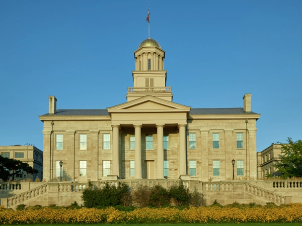
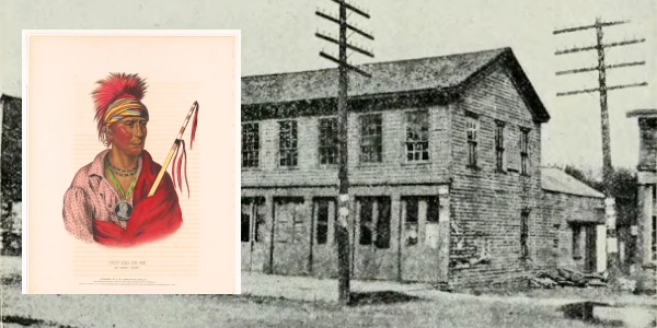
Image above: Building known as the Old Stone Capitol, Iowa City, the former Iowa Territory capitol built in 1840, 2016, Carol M. Highsmith. Courtesy Library of Congress. Below: Montage (background) original building used for the Iowa Territory legislature in Iowa City in 1841, here seen as a later hotel, 1903, History of Iowa from the Earliest Times to the Beginning of the Twentieth Century, Volume 1. Courtesy Wikipedia Commons. (inset) lithograph of Ioway chief, Not-Chi-Me-Ne, 1838, John T. Bowen. Courtesy Library of Congress. Info Source: "Stories of Iowa," Iowa History Project; "Territorial History of Iowa," history.rays-place.com; "The History of Black Hawk County," 1878, Western Historical Company; Wikipedia Commons; Library of Congress.
History Photo Bomb
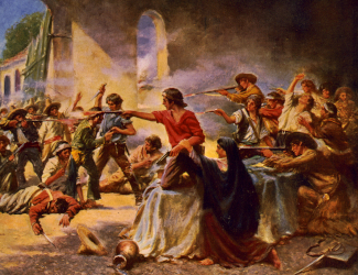
The painting of the Alamo by Percy Moran, 1912, reflects the
intensity of the battle in San Antonio. Courtesy Library of Congress.
ABH Travel Tip
Don't forget to look into many state historic sites when visiting the National Parks of the area. These sites, although smaller in scale than the National Historic Sites in many instances, carry a plethora of interesting tidbit about the nation's history that you don't want to miss.
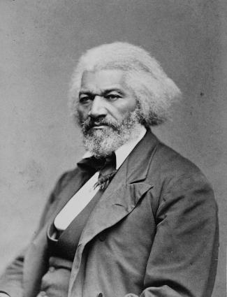
Frederick Douglass, 1879. Courtesy National Archives.
Timeline Book


A reenactment of a wagon train on the Oregon Trail brings back the time of the great migration west at national historic sites such as Scotts Bluff National Historic Site. Photo courtesy National Archives.