-
Sand to Snow National Monument
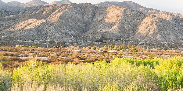
Valley to mountain scene at Sand to Snow National Monument. Image courtesy Bureau of Land Management.
Associate Pages
-
Visitor Statistics
Visitors - 75,000 to 125,000 San Bernardino National Forest, including 50,000 to the San Gorgonio Wilderness.
Sand to Snow National Monument
Park Size
Sand to Snow National Monument
71,000 acres of the San Bernardino National Forest
83,000 acres of the California Desert region BLM
Park Fees
Free
Weather
This is desert California, with parts at high elevation. It is very hot here in summer, over 100 degrees many days, plus in the months surrounding it. Please plan accordingly and check the weather conditions and reports often. Water is imperative, even on a short hike. In summer, consumming 1 quart per hour you hike is a good idea. Always hike within your capacity and try to stay indoors or in shade in the midday. In winter, the San Gorgonio Mountains, at 11,500 feet, gets plenty of snow and cold weather, thus extreme winter conditions. There is no month atop the mountain where the average temperatures exceeds fifty degrees. Plan accordingly and stay abreast of all weather conditions to stay safe.
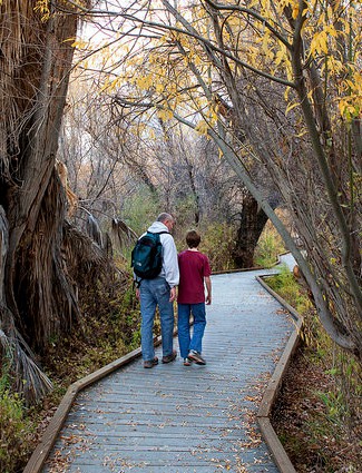
Photo above: Walking trail at Sand to Snow National Monument. Photo courtesy BLM. Right: San Gorgonio Mountain. Source: Wikipedia Commons.

Sand to Snow National Monument
Talk about new and old at the same time. On February 12, 2016, President Barack Obama announced the creation of Sand to Snow National Monument, culling together two distinct federal lands (a section of San Bernardino National Forest and part of the California Desert region of the Bureau of Land Management) into a distinctly named and distinctly different national monument. For now, it's being managed in the same fashion as before, with the same amenities, with plans for the monument, visitors centers, and signage still in the planning stages. But for those of you who've already witnessed the variety of history, nature, and recreation available, it will be per usual. For those who didn't even know this area existed, which is a bit hard to do with 24 million people living within a two hour drive, take a drive into the monument some weekend and see for yourself. Sometimes, even many times, we don't realize what's around us until it's pointed out. And this time, by a cool name.
Sponsor this page. Your banner or text ad can fill the space above.
Click here to Sponsor the page and how to reserve your ad.

Sand to Snow Then
For over 2,500 years, the Takic subset of the Uto-Aztecan native americans called the area home. For the people of the Serrano and Cahuilla tribes, the San Gorgonio Mountain, or Old Greyback, was a sacred place. They lived at the foot of its 11,503 feet and used the mountain pass to travel to the coast. The mountain is the 7th highest peak in the lower forty-eight states. This was also true for the Serrano of the Black Lava Butte, which contains over 1,700 petrogryphs and stands testament today to their culture.
When the Spanish came in the late 1700s, they constructed Rancho San Gorgonio, the eastern outpost of the San Gabriel Mission. Fathers from the mission would drive their wagons through the San Gorgonio Pass to the Salton Trough in the desert to get salt from the flats. The San Gorgonio Mountain Pass had been the main thoroughfare through the mountain peaks for centuries, a three to five mile valley between San Gorgonio Mountain to the north and San Jacinto Mountain to the south, both over ten thousand feet. It, in many ways, was given its current imprimatur when Congress, in 1853, decided to send a party of engineers to California to determine the best path from the Mississippi River to the Pacific. Who told them to go? Jefferson Davis, Secretary of War at the time. Once reaching the San Gorgonio Pass, the geologist of the party knew of its importance immediately and it became the stage coach and railroad gate through the mountains, precipitating the subsequent settlements that would follow.
William F. Holcomb and Ben Choteau found gold in the Holcomb Valley in May 1860, five miles north of Big Bear Lake, and this rush, although unsuccessful overall compared to other rushes, brought miners, farmers, and additional settlers to the area, created a boom town in Belleville of 1,500 and claims whose remnants still dot the countryside inside Sand to Snow. Recreation in the area began in earnest in the 1920s.
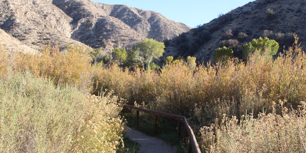
Photo above: Photo above: Hiking Trail, Sand to Snow National Monument. Photo courtesy BLM. Below: Trail leading from the valley to the mountains at Sand to Snow National Monument, courtesy Bureau of Land Management.
Sand to Snow Now
Unique in its variety, Sand to Snow is what its name denotes, a place of desert and mountain snow. When President Obama announced its formation through the 1906 Antiquities Act, it became the fourth federal monument to be managed jointly by the United States Forest Service and the Bureau of Land Management. Not that the idea of a national monument is new to the area. In 1923, Harry C. James walked a petition into the office of President Calvin Coolidge. Yes, ninety-three years in the making. It's still to be seen what shape that will take, but for now, the 151,000 acres of wilderness, desert, and mountains remain as they've been for centuries, wild and vast and open to enjoy, both for its valley sand where trialheads lead into the wilderness for hiking adventures and its mountain snow where cross-country skiers do the same. Along the way, you might get to witness a number of the 240 different species of birds that live here, or have a camp night out in a primitive location where missionaries and tribe members once did.
Today, the area contains a plethora of recreation activities, from hiking to fishing to sightseeing. You can camp, bird watch, cross country ski, fish, horse back ride, and mountain bike, too. The monument itself, being so new, is an additional step in bridging the history and recreation heritage, pulling together their partners in the communities surrounding it, plus the private preserves on its border. They are still in the planning stages as to how all that will be accomplished. Stay tuned.
T-Shirts and Souvenirs

Sand to Snow National Monument T-Shirts and Souvenirs from the official merchandise of America's Best History.
Sand to Snow
Things You Should Not Miss
1. Head to the Ranger Station at Mill Creek for orientation, wilderness camping permits, and hiking suggestions. Whether this area will become the final location for a Visitor Center is still far from determined. For now, head there, and start your Sand to Snow adventure. For some, heading to one of the surrounding preserves and their trailheads will take you into the monument. White Water, Mission Creek, and Big Mongo Preserves provide orientation to the area as well.
2. Hike. Pretty simple really. It's one of the main joys of seeing the nature that abounds at every corner. The Pacific Crest trail is just one of many. Thirty miles of that two thousand and six hundred mile path lies within Sand to Snow National Monument. Remember to only hike to your abilities and bring plenty of water and supplies.
3. If you've got a greater need for progress than a hike, take in a San Bernardino National Forest Greyback Amphitheatre program. Located just off Route 38 not far from the border of Sand to Snow.
Photo above: Sand to Snow National Monument. The trails in the park have been traversed by the Serrano Indians, missionaries, and miners for thousands of years. Source: BLM.

Paint the history of Baseball number by number in books and stats you can get nowhere else. Baseball Evaluation @
statgeekbaseball.com.
Visitor FAQ

What's There Now
Sand to Snow National Monument
Mill Creek Ranger Station - Best place to get orientation about the park inside the borders of Sand to Snow. You can get your Wildernss Camping Permit here.
Pacific Crest Trail - Thirty miles of the 2,600 mile trail goes through the monument.
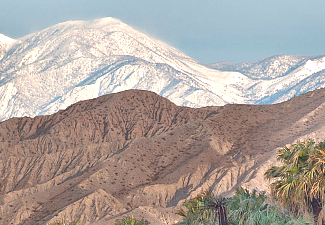
San Gorgonio Mountain. It rises above the desert floor to a height of 11,503 feet. Make sure, even if hiking that far or high isn't in your wheelhouse, to get a glimpse. It's pretty easy to see, even from one hundred and ninety miles away.
Photo above: View of the San Gorgonio Wilderness. Courtesy Bureau of Land Management.

Directions to the Park
Sand to Snow National Monument is located south of Route 38 and North of Interstate 10, thirty-one miles east of San Bernardino. From San Bernardino, take Greenspot Road east to Route 38 east. You can also get into the monument on the eastern Bureau of Land Management side by traveling north off Interstate 10 on Route 62.
Photo above: Camping at Sand to Snow National Monument. Image courtesy Bureau of Land Management.
Lodging and Camping
There is no lodging within the acreage of the park. You can check your favorite online lodging site for the motel, hotel, or bed and breakfast of your choice.
There are a few developed campsites within the Sand to Snow National Monument itself, but many more just outside the Monument boundaries in the rest of the San Bernardino National Forest. Backcountry wilderness camping is available throughout both. You need a permit for that, which can be obtained at the Mill Creek Ranger Station. They're free.
Developed Site: Coon Creek Yellow Post Site and Group Campgrounds. 19 campsites at Yellow Post and the group campground can handle 25 people and 10 vehicles. No water or restrooms.

Sand to Snow National Monument Links
Sand to Snow - National Forest Service
Sand to Snow - Bureau of Land Management