-
Sáttítla Highlands National Monument
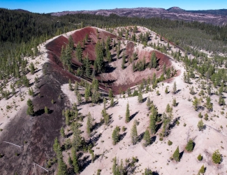
Paint Pot Crater within Sáttítla Highlands National Monument. Courtesy United States Forest Service/Bob Wick.
Associate Pages
-
Visitor Statistics
Not Available
Sáttítla Highlands National Monument
Park Size
Sáttítla Highlands National Monument
224,676 Acres (Federal and Total).
Park Fees
Free
Medicine Lake Recreation Area, $5 day and dock use. Camping fees do apply, $15 per night at the four campgrounds near Medicine Lake. Backcountry and roadside camping in undeveloped areas was allowed, check at the Ranger Station if that has changed or now requires a permit.
Weather
It's Northern California weather at elevation combined with the inland Pacific Northwest. Summer high temperatures average in the 75-80 degree area; winter high temps in the 40's on average. You are high in the mountains at some points of the park and weather can change quickly. Stay tuned to the local weather forecast to keep abreast of weather conditions to have a safe and pleasant experience.
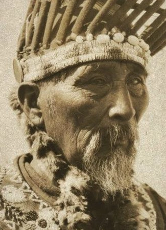
Photo above: Istet Woiche, William Hulsey, historian of the Madesi tribe, a band of the Pit River Tribe, 1923, Author Unknown. Courtesy Wikipedia Commons. Right: Water and mountain scenery at Sáttítla Highlands National Monument. Courtesy United States Forest Service/Bob Wick.

Sáttítla Highlands National Monument
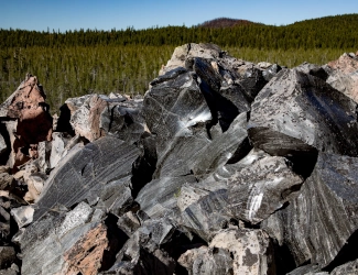
Okay, the name is from the Ajumawi language, easy to say when you know the pronunciation, but harder to code. Okay, enough about us. The translation is obsidian place, or from a dictionary sense, a hard, dark, glasslike volcanic rock formed by the rapid solidification of lava without crystallization. This is a volcanic place. The Medicine Lake Volcano is ten times as large as Mt. Saint Helen's. This place and its deposits are important to the Native Americans who lived, and still live here. Home to and sacred to the Pit River and Modoc Tribes. Today, as a National Monument designated during the Biden administration, it is a place of Native heritage, with moonscapes, dark night skies, and recreation. You can camp here. You can hike here. You can snowmobile here, as well as hunt and canoe.
Sponsor this page. Your banner or text ad can fill the space above.
Click here to Sponsor the page and how to reserve your ad.
Sáttítla Highlands National Monument Then
Human habitation of the area has been dated back five thousand years. It is part of the creation story of the Pit River Tribe. For the Modoc, the highlands and volcanoes were core to their ceremonial lives. They are not the only tribes that find the highlands significant; the Karuk, Klamath, Shasta, Siletz, Wintu, and Yana also see the landscape as part of their heritage as well. The core of the National Monument is Medicine Lake Volcano. It is dormant, but has many lava flows that geologists call young, that is under thirteen thousand years old. And how far do those lava flows reach? Try thirty miles. When was the last time the volcano blew? Between three thousand and nine hundred years ago.
So you'd think, as considered dormant, that it would not blow during your stay. For the most part, you would be right. But Mt. Saint Helen's proves that you never truly know about volcanoes. And the history of Medicine Lake Volcano has a long history before that which suggest its latent activity should not be taken for granted.
So how does the United States Geologic Service describe this volcanic area, "The eruptive activity at Medicine Lake volcano is probably driven by intrusions of basaltic magma that occur during east-west stretching of the crust in an extensional tectonic environment." Good to know.
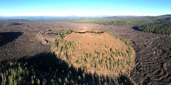
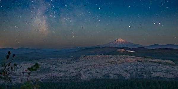
Photo above: High Hole Crater. Courtesy United States Forest Service/Bob Wick. Below: View from Mount Hoffman toward Little Glass Mountain Obsidian Flow in foreground and Mount Shasta in distance. Courtesy United States Forest Service/Bob Wick.
Sáttítla Highlands National Monument Now
With its history of volcanic activity and myriad of recreation already taking place there, Senator Alex Padilla urged for legislation to protect it from development. President Biden agreed, designating the Medicine Lake Volcano and highlands that had been within the Klamath National Forest, Shasta-Trinity National Forest, and Modoc National Forest as a National Monument. It is located not far from the Oregon border, northeast of Mount Shasta. There are numerous lava and cinder cones to explore. One of the best ways is to drive the part of the Volcanic Legacy Scenic Byway which traverses the park around Medicine Lake.
But recreation in the area has been a buzzword for a long time during their National Forest days. In fact, almost all of that will continue as the National Forest Service will continue to administer and run the National Monument. The McLoud Ranger Station can help you get oriented if you have not been there before. It is located in McCloud, California on Route 89. The Giant Crater is located two miles off Medicine Lake Road, Route 49. But be prepared with supplies before you head off Route 89, ... there are no services past there.
T-Shirts and Souvenirs

Sáttítla Highlands National Monument T-Shirts and Souvenirs from the official merchandise of America's Best History. Great for fans of the new National Monument in northern California.
Sáttítla Highlands NM
Things You Should Not Miss
1. First, especially with the National Monument in its early phase of transition, and with the monument plan to come. Probably a Visitor Center or expanding the one at McLoud will be part of it. We have no knowledge of that, just a guess. For now, it's a must for first time visitors to go to the McLoud Ranger Station on Highway 89. They can tell you where the best hikes are and where you are allowed to camp. As noted in other places, once off Highway 89 and back into the park, there are no services.
2. Hike. There are so many trails to choose. Bring plenty of water and snacks. A must is going to Medicine Lake. And for those that like such things, hike into the wilderness and spend a couple days primitive camping. There could be new restrictions with National Monument status, ask at the ranger station.
3. Drive the portion of the Volcanic Legacy Scenic Byway around Medicine Lake, and once you are there, it's only two miles off Route 49 to get to the Giant Crater. But don't be too amused by that one place, this is a land full of glass mountains, cinder cones, and lava flow remnants around every corner.
Visitor FAQ
What's There Now
Sáttítla Highlands National Monument
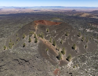
So much to see, but almost all of it is God made, not man made, so don't expect buildings. Just craters such as Giant Crater, Pumice Crater (used by NASA to train its astronauts), Paint Pot Crater, and more. Spatter cones. Cinder cones, over one hundred. Glass Mountain, fifteen minute drive from the campgrounds mentioned below, Little Glass Mountain, and the Burnt Lava Flow Geologic Area. And then there are the lava flows; from Giant Crater itself, they stretch thirty miles. At the recreation area, there is camping, boating, fishing and swimming at a designated sand beach, plus mountain biking trails.
Lodging and Camping
There is no lodging within Sáttítla Highlands National Monument, but some can be found in the towns surrounding Siskiyou County, but not lots. Your best bet is McLoud with three hotels and a number of bed and breakfasts or lodges. There are campgrounds in the Medicine Lake Recreation Area, all formerly part of Modoc National Forest. They are at high elevation, 6,770 feet, but have sites amid large lodgepole pines. It can be windy here and the season is short, July 1 to October 1. There is a hiking trail from here to the Medicine Lake Lava Flow.
As of now, this area has four campgrounds; Medicine, A.H. Hogue, Hemlock and Headquarters Campgrounds. There are vault toileets and water hydrants. Recreational vehicles can fit in nineteen of the spaces. Fifteen of the seventy-five can be reserved in advance. These campsites are forty-eight miles from McLoud. There may be others within Sáttítla Highlands that were part of other National Forests, but the current website is a bit shy on that information.
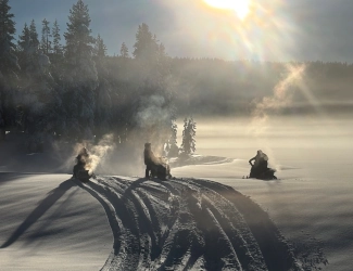
Photo above: Snowmobiling in the National Monument. Courtesy United States Forest Service/Thomas Stansberry.
History of Medicine Lake Volcano
Even though dormant, and considered young due to its last eruption only nine hundred to three thousand years ago, it has been a remarkably active volcanic area through the history of earth. There have been five stages of volcanic activity at the site. Stage One - Started half a million years ago and lasted until three hundred thousand years ago. Stage Two - Sixty-nine of the eruptions occurred during this period, 300 ka to ~180 ka. Yeh, I know, what does ka mean to geologists? About one thousand years in time. Stage Three - Known as the period of Caldera-rim construction (~180 ka to 100 ka), the eighty eruptions were predominantly basalt in type. Stage 4 - Its name, Big Basalts (<100 ka to ~13 ka) were fewer in number, twenty-four, but much larger, covering nearly half of the entire Medicine Lake Volcano area.
Stage Five runs from (~12.5 ka to the present). This is the postglacial period. It is thought that seventeen eruptions have happened during this stage, about one to two per century. A large amount of the area was created during the Giant Crater eruption after the end of the glacial period. It is thought to have occurred during the stress put on the land by the melting of the glacial ice, causing a pressure release. Eight thousand years after that, three eruptions occurred during the period of 3,000 to 900 years ago. Wonder if it is due.
Photo above: Medicine Lake Highlands Volcanp, Giant Crater, with Lava Tubes. Courtesy United States Forest Service/Bob Wick.
Native American Heritage
A sacred home and ceremonial grounds have been part of the heritage of the Pit River Tribe, Modoc, Karuk, Klamath, Shasta, Siletz, Wintu, and Yana. To the Modoc, they consider Medicine Lake a place of healing, not only in its water but on the banks they call Laníshwi. There are eighty-five plant species in the area. These were used to create medicine, food, build tools, and dye clothes, using ichen.
The Pit River tribe was instrumental in gaining protection of the lands of the highlands, to prevent development, particularly in an area of such geothermal activity, and respect their heritage and sacred sites.
Photo above: Little Glass Mountain. Courtesy United States Forest Service/Bob Wick.
