-
Timeline - The 1980s
Prosperity comes again and the Cold War ends. Plus there's Olympic triumphs and controversy, the personal computer age born, and a Supreme Court justice with a difference.
More 1900s
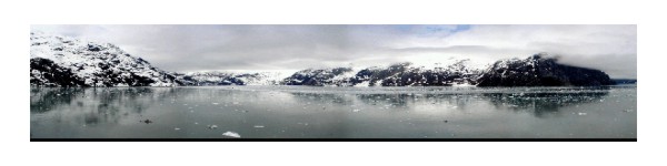
Exxon Valdez spill in Alaskan waters raises concerns about the environmental impacts of man-made disasters on our natural lands and waters.
Sponsor this page. Your banner or text ad can fill the space above.
Click here to Sponsor the page and how to reserve your ad.
-
Timeline
1980 - Detail
May 18, 1980 - The Mt. St. Helens volcano, in Washington State, erupts, killing fifty-seven people and economic devastation to the area with losses near $3 billion. The blast was estimated to have the power five hundred times greater than the Hiroshima atomic bomb.
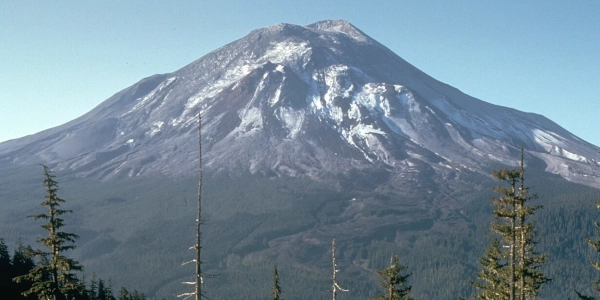
It was a Sunday morning, early, 8:32 a.m. when a 5.1 measured earthquake shook the Northwest and the Richter scale. What had been a tall symmetrical mountain immediately took a different shape. The North Face of Mount St. Helens, known as Lawetlat'la to the historic Cowlitz tribe of the area, could not withstand a lateral hydrothermal blast that became an avalanche, the largest debris avalanche in earth's history. It traveled over a thirteen hundred foot ridge, slammed into Spirit Lake, and rumbled fourteen miles into the Toutle River. The pressurized gas within the volcano cryptodome released into the forests surrounding it, ... for one hundred and fifty square miles. The USGS began sighting Magma intruding into the mountain during the late winter and early spring, but the first major alert happened on March 16 with a series of small earthquakes, including the largest pre May earthquake of March 20 at 4.1 on the Richter Scale. On March 27, the first release in one hundred years spew steam explosions and ash. A few homeowners had not heeded these warnings, they would be immediately inundated by the ash and never found once the main explosion blew.
The warnings had been dire. In early April, the diameter of the crater had grown one thousand three hundred feet. A bulge had grown on that North Face. What did this mean? The molten magma was rising. It created an atomic bomb style mushroom cloud, but this time five hundred times stronger. Hot pumice poured from the crater for nine hours. 3.3 billion cubic yards of debris covered the mountain and surrounding forest. The plume rose to fifteen miles in height. A Pumice Plain covered five miles of land to its north in what is known as the Plinian phase.
Five hundred and forty million tons of ash blew east; it became dark in daytime Spokane. In three days, the ash cloud crossed the Continental United States; it took fifteen days to circle the globe. On the ground, a slurry of glacier ice and groundwater pushed down the North Fork Toutle River, destroying bridges and homes. It flowed into the Cowlitz River, fifty miles from the volcano.
Devastation
The outcome of the explosion would be the most costly in United States history. Fifty-seven people would die. Two hundred homes would be destroyed. Dozens of miles of railroad, highways, and forty-seven bridges were gone. The mountain, which had been 9,677 feet high had now been lowered to 8,363. It took six years, but the lakes returned to normal. Only five of the eleven pre eruption glaciers would return.
Of course, the 1980 eruption had been far from the first. Even just starting from the oral writing period around the year 1800, when the Goat Rocks period eruption began; that eruption likely was similar in size to that in 1980. Another moderate eruption occurred in 1842. Even after the devastating 1980 earthquakes, there have been smaller eruptions over the years, most contained within the caldera. It is said by some scientists that another, even larger, earthquake, is only a matter of time at Mount St. Helens, before it occurs.
Minute Walk in History
Mount St. Helens Erupts
Through film, photos, and video, watch as the former symmetrical dome of Mount St. Helen's is reduced in the drastic explosion that occurred on May 18, 1980. Today, Mount St. Helens is a National Monument run by the National Forest Service, and is monitored daily by the United States Geological Service.
Watching for Volcanic Activity
Cascades Volcano Observatory, operated by the United States Geological Serivce, monitor ground activity in Washington, Oregon, and Idaho. The last major eruptions at Mount St. Helen's occurred in 1986. In 2025, there have been minor earthquakes in the area of Mount Rainer, Mt. St. Helens, and Mount Hood. There is a volcano alert system that grades any danger; NORMAL, ADVISORY, WATCH, and WARNING.
Mount St. Helens Today
Today, Mount St. Helens is a National Monument within Gifford Pinchot National Forest. Yes, it is unusual to have a National Monument run by the Forest Service, but there are about one dozen now and growing. Not our preference, but it's our governments way to confuse people and create bureaucracy. There are one hundred and ten thousand acres surrounding the mountain to protect the landscape, visitors, and land owners just outside it, unlike which occured when the Mount St. Helens blew forty odd years ago. There is a Visitor Center, trails throughout, and it is possible to climb to the caldera, four thousand eight hundred feet above sea level. A limited number of permits for that are handed out daily. Call ahead to register. The hike is dangerous and care should be taken seriously. There has been a death with a hiker falling into the center of the volcano.
Two years after the explosion, President Carter designated the acreage as that National Monument to protect, memorialize, and provide safe access to the area. The volcano remained active until 1986, further creating the cone. The lava dome is now nine hundred and twenty feet high.
For first time visitors, it is imperative that you stop at one of the Visitor Centers or information kiosks to get further information about hiking, walks and talks by Park Rangers, and camping opportunities. There are those trails as well as park roads to explore. Over the last forty-five years, the forest and its creatures have rebirthed themselves. No, the mountain does not look the same. It's different. But there are places where you can certainly see the devastation in the burnt out stems of trees that witnessed the horrid explosion.
Access to the park is most easily done off Route 504, where the Johnston Ridge Observatory (exhibits and movie) and Forest Learning Center are located. There are helicopter tours, caves to explore nearby, and horseback riding. Lodging is closest by in Kelso, Washington. Gifford Pinchot National Forest has nearly twenty campgrounds. A few private campgrounds are closer to the National Monument itself. Primitive camping is allowed in the park; ask where. Some good sites are available on the southern side of the park.
Photo above: Mount St. Helen's erupting on May 18, 1980, 1980, Austin Post. Courtesy United States Geological Service (USGS). Photo below: Mount St. Helens's Day Before 1981 Eruption, 1980, Harry Glicken. Courtesy United States Geological Service (USGS). Source: United States Forest Service; United States Geological Service; Wikipedia; mountsthelens.com; "The Southern Flank of Mount St. Helens Offers Primitive Camping Opportunities," Cade Barker, thereflector.com.
History Photo Bomb

Sally Ride, America's first woman astronaut, communities with
NASA from the flight deck of the Challenger Space Shuttle, June 18-24, 1983. Photo: U.S. Information Agency.
Timeline History

Now in easy to search digital format for your Kindle, Nook,
or pdf format. Also comes in paperback, too.

President Reagan at the Berlin Wall. Courtesy National Archives.
ABH Travel Tip

Take a trip along the Appalachian Trail. There are a myriad of National Park and other historic sites either on the trail or just nearby. From Acadia National Park in Maine to Harper's Ferry National Park in West Virginia, plus other Civil War sites nearby, down to Georgia. So you can take a hike, visit some history, and see a whole lot a nature and beauty along the way.

Crowds of the Civil Rights March in Washington, D.C. surround
the Washington Monument. August 28, 1963. Courtesy National Archives.
Watching for Volcanic Activity
Cascades Volcano Observatory, operated by the United States Geological Serivce, monitor ground activity in Washington, Oregon, and Idaho. The last major eruptions at Mount St. Helen's occurred in 1986. In 2025, there have been minor earthquakes in the area of Mount Rainer, Mt. St. Helens, and Mount Hood. There is a volcano alert system that grades any danger; NORMAL, ADVISORY, WATCH, and WARNING.
Mount St. Helens Today
Today, Mount St. Helens is a National Monument within Gifford Pinchot National Forest. Yes, it is unusual to have a National Monument run by the Forest Service, but there are about one dozen now and growing. Not our preference, but it's our governments way to confuse people and create bureaucracy. There are one hundred and ten thousand acres surrounding the mountain to protect the landscape, visitors, and land owners just outside it, unlike which occured when the Mount St. Helens blew forty odd years ago. There is a Visitor Center, trails throughout, and it is possible to climb to the caldera, four thousand eight hundred feet above sea level. A limited number of permits for that are handed out daily. Call ahead to register. The hike is dangerous and care should be taken seriously. There has been a death with a hiker falling into the center of the volcano.
Two years after the explosion, President Carter designated the acreage as that National Monument to protect, memorialize, and provide safe access to the area. The volcano remained active until 1986, further creating the cone. The lava dome is now nine hundred and twenty feet high.
For first time visitors, it is imperative that you stop at one of the Visitor Centers or information kiosks to get further information about hiking, walks and talks by Park Rangers, and camping opportunities. There are those trails as well as park roads to explore. Over the last forty-five years, the forest and its creatures have rebirthed themselves. No, the mountain does not look the same. It's different. But there are places where you can certainly see the devastation in the burnt out stems of trees that witnessed the horrid explosion.
Access to the park is most easily done off Route 504, where the Johnston Ridge Observatory (exhibits and movie) and Forest Learning Center are located. There are helicopter tours, caves to explore nearby, and horseback riding. Lodging is closest by in Kelso, Washington. Gifford Pinchot National Forest has nearly twenty campgrounds. A few private campgrounds are closer to the National Monument itself. Primitive camping is allowed in the park; ask where. Some good sites are available on the southern side of the park.
Photo above: Mount St. Helen's erupting on May 18, 1980, 1980, Austin Post. Courtesy United States Geological Service (USGS). Photo below: Mount St. Helens's Day Before 1981 Eruption, 1980, Harry Glicken. Courtesy United States Geological Service (USGS). Source: United States Forest Service; United States Geological Service; Wikipedia; mountsthelens.com; "The Southern Flank of Mount St. Helens Offers Primitive Camping Opportunities," Cade Barker, thereflector.com.
History Photo Bomb
Sally Ride, America's first woman astronaut, communities with
NASA from the flight deck of the Challenger Space Shuttle, June 18-24, 1983. Photo: U.S. Information Agency.
Timeline History
Now in easy to search digital format for your Kindle, Nook,
or pdf format. Also comes in paperback, too.
President Reagan at the Berlin Wall. Courtesy National Archives.
ABH Travel Tip
Take a trip along the Appalachian Trail. There are a myriad of National Park and other historic sites either on the trail or just nearby. From Acadia National Park in Maine to Harper's Ferry National Park in West Virginia, plus other Civil War sites nearby, down to Georgia. So you can take a hike, visit some history, and see a whole lot a nature and beauty along the way.
Crowds of the Civil Rights March in Washington, D.C. surround
the Washington Monument. August 28, 1963. Courtesy National Archives.