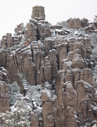
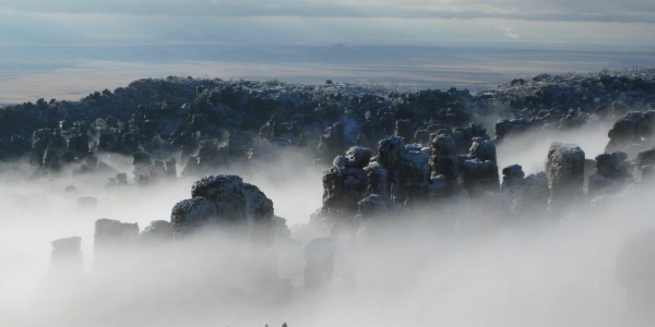
Image above: Rising rocks in the snow at Chiricahua, unknown. Courtesy National Park Service.
Spotlight on Lesser Known History
Chiricahua National Monument, Arizona
America's Best History Spotlight
On this page we're going to Spotlight the lesser known historic sites and attractions that dot the history landscape across the USA and are worth a visit if you're in their area. And while they may be lesser known, some are very unique, and will be that rare find. You'll be, at times, on the ground floor, or maybe even know something others don't. It'll be fun. Visit them.

Chiricahua National Monument, Arizona
There's an effort going on to upgrade Chiricahua National Monument in Arizona to a National Park, and we believe they should do it. The national monument is surrounded by both the Chiricahua Mountains and land of the Coronado National Forest. As the National Park Service has been having overcrowding issues at its most popular national park, i.e. Grand Canyon and Yellowstone, they have been implementing timed tickets and reservations for entry, which, although we disagree with, has prompted many to think that certain National Monuments should be enlarged and made into full National Parks. National Monuments, in general, gain lesser attendance, in part due to the name. While we don't quite understand that logic, it is true. As a National Monument, Chiricahua gains an attendance less than 80,000 visitors per year. As a National Park, it would likely rise to over five hundred thousand. However, that's not to say you shouldn't go visit this spectacular National Monument now. You should. With the way government works, it could take twenty years for Chiricahua to rise to its next logical level.
Image above: Big Balanced Rock at Chiricahua National Monument (Park), date unknown. Courtesy National Park Service.
Sponsor this page. Your banner or text ad can fill the space above.
Click here to Sponsor the page and how to reserve your ad.
Info, What's There Now, History Nearby
Chiricahua National Monument, Arizona
In its current status, Chiricahua is a great place to camp and hike amongst amazing scenery. There is a Visitor Center for orientation and Ranger Programs listed on the board there. They don't seem to understand the calendar on their site at all times. You should not miss Faraway Ranch, the trails running west from the Bonita Canyon campground or east from Bonita Creek. They are actually two trails which meets; Bonita Creek Trail (west) and Silver Spur Meadow Trail (east). Along this path is Faraway Ranch and the Stafford Cabin.
Further west along the tour road are the formations and sites, some sightable from the pulloffs, others needing a hike, of the Organ Pipe Formation and Natural Bridge, Sea Captain and China Boy, Sugarloaf Mountain with trail, Echo Canyon with grotto, Exhibits at the western turnaround at Massai Point. Long trails spur off the main road from various locations, but most require experience and capability and lots of water to traverse them. Particularly strenuous are the long trails of Heart of Rocks Loop 7.3 miles, Inspiration Point Trail 5.4 miles, and the Big Loop Trail 9.5 miles.
Fort Bowie is also located nearby just north of Chiricahua National Monument. While at one, you shouldn't miss the other.
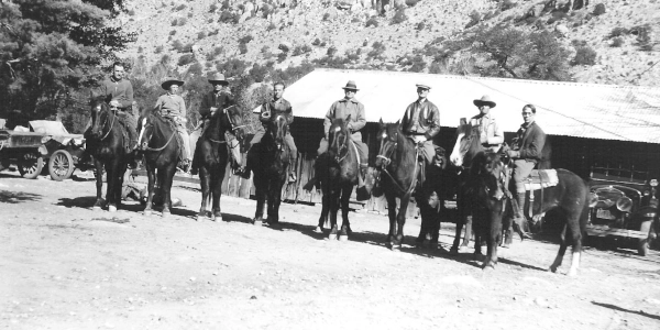
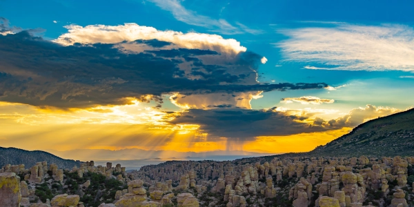
Image above: Horseback riders coming to see Wonderland of Rocks at Faraway Ranch, unknown date. Courtesy NPS/WACC. Below: Amazing skies above the rock formations, unknown date, R. Stewart. Courtesy National Park Service.
Where Is It
The Chiricahua National Monument is located at 13063 East Bonita Canyon Road, Willcox, AZ 85643. It is south off of Interstate 10, taking AR 186 east from Willcox, Arizona for approximately thirty miles.
Minute Walk in History
There's an effort going on to upgrade Chiricahua National Monument in Arizona to a National Park, and we believe they should do it. The national monument is surrounded by both the Chiricahua Mountains and land of the Coronado National Forest. Watch some of the spectacular scenery here now, then travel to southwest Arizona and hike, camp, and view the amazing scenery.
What is There Now
Chiricahua National Monument, Arizona
Twelve thousand acres surround the main Bonita Canyon Road which reaches into the center of the park. Surrounding this area is wilderness both to the north and south. There is a campground, also known as Bonita Canyon (only place to camp here, no primitive camping allowed), from which a trail takes you to Faraway Ranch. South of the farthest east on the park road sits some of the most spectacular rocks, like Big Balance Rock. You must hike into that area to see it, but if capable, definitely worth the hike. The Visitor Center is located 3.5 miles into the park, prior to the campground. The park only has one main, paved road, access. Other primitive roads enter through Coronado National Forest, but are not used by most visitors.
When Open and How Much
The walking trails are open twenty-four hours per day and there is no entrance fee. The Visitor Center, exhibits, and film is open daily, except for major holidays, from 8:30 to 4:30. There are facilities, interpretation, and a gift shop there as well. Summer weather is often cooler than most Arizona locations due to the elevation of Sugarloaf Mountain; it also means that winter can bring snow and below freezing temperatures.
Fees and hours are subject to change.
Website
Chiricahua National Monument
History Nearby
There are three National Parks in Arizona as of July 2005. Yes, they are famous. Grand Canyon, Saguaro, and Petrified Forest National Park. Of course, there are many other sites to see in the state, including a multitude of National Monument, of which Chiricahua is attempting to leave as a status. Either way, it's a wonderful park to visit as are the others in the entire state.
Photos, History, and More Spotlights
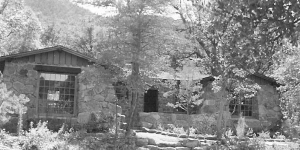
Faraway Ranch
The history of Faraway Ranch reaches back to the Erickson family, Emma and Neil. Yes, Swedish. The homesteaded a one hundred and sixty acre tract with two room cabin one month before their marriage in January 1887. They had three children, thus expanding the cabin. Farming, however, was difficult, thus Neil worked as a carpenter several months a year away from the homestead. In 1903, when the area became the Chiricahua Forest Reserve, Neil Erickson became the first park manager.
Daughter Lillian, after marrying Ed Riggs, expanded the house further and invited guests to stay. There was a pool, hiking, horseback riding and more during this era. The area is now termed the Faraway Ranch Historic District, including the Faraway Ranch House, the Cowboy House, Neil's Den, barns, and other outbuildings.
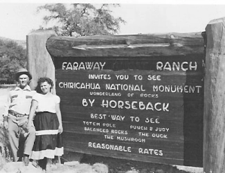
Photo above: "Faraway Ranch invites you to see Chiricahua National Monument, wonderland of rocks, by horseback. Best way to see Totem Pole, Punch&Judy, Balanced Rocks, the Duck, the Mushroom. Reasonable Rates," unknown date. Courtesy NPS/WACC/Faraway Ranch Collection.
Buy Second Edition
America's Best History Timeline

Great book to keep middle school to college students up to date on their American history.
Campaign for National Park Status
Today as a National Monument, Chiricahua only draws 71,390 (2024) visitors per year, although since that is a Visitor Center count, park rangers think the number is actually about double. This number would grow substantially if given National Park status by Congress, as well as draw visitors from other overcrowded parks. Although today the park is only around twelve thousand acres, which would make it a small national park. If given National Park status, there could be incorporation of part of the much larger Coronado National Forest which includes the Chiricahua Mountains.
Efforts have been mulled about for a number of years, but in 2022, things seemed to become more serious. Citizens and Arizona politicians for expanding the park and gaining National Park status began in the U.S. Senate for this part of the Arizona Sky Islands. Due to its seclusion within the forty mile mountain range, an update would seriously expand its reach, as well as keep mining interests at bay. The bill would pass the Senate in 2023, but not be taken up by the House of Representatives, thus failing to pass. It would be reintroduced as support by both Senators are backing the legislation, but as of 2024, the House of Representatives was in subcommittee and there had been no vote.
Residents on the east side of the park, where entrance is only by a gravel road closed in winter, are less favorable than those to the west toward Willcox. Trival nations are not that favorable as well. Park employees doubt much would physically change, unless expansion onto private land, or inclusion of some of the land of the Coronado National Forest would occur.
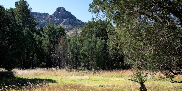
Image above: Silver Spur Meadow at Chiricahua National Monument (Park), 2014, C. Dischinger. Courtesy National Park Service. Below: Snow over the spires, 2013, C. Heupel. Courtesy National Park Service.
Then and Now
On April 18, 1924, President Calvin Coolidge designated the land as a national monument. It was later expanded by President Franklin Delano Roosevelt. The original Visitor Center was built by the Civilian Conservation Corps. Today, a modern Visitor Center awaits, and a shuttle is available in the morning to take hikers to far off points; they have to hike back we're told.
Lodging is only available in the Bonita Canyon Campground, just northeast of the Visitor Center. It has twenty-three sites in a wooded setting, flush toilets, but no showers. Nightly fee is $25 as of 2025. Campsites must be reserved. The park amphitheater is located nearby. No primitive camping is allowed in the park. Primitive camping is available on Pinery Canyon Road, six miles outside the park.
Photo above: Original Visitor Center at Chiricahua National Monument, 1941, Dodge, Fish, and Ebermeyer. Courtesy National Park Service.
T-Shirts and Souvenirs

Chiricahua National Monument (National Park) T-Shirts, Sweatshirts, Backpacks, and other souvenirs from the official gear of americasbesthistory.com.

May Spotlight
Violet Bank, Virginia

July Spotlight
Francis Perkins NM, Maine
