They came, in colonies settled around Jamestown, with the
pilgrims at Plymouth Rock in the Massachusetts Bay, and they began what we would term the America of today. There would be treaties with the Indian nations and battles amongst warring tribes. There would be contests of wills between colonies funded and founded by British, Spanish, and French concerns. But this would be the century that began true settlement, for all its wonder and hardship and harbinger of a nation that would come.
July 6, 1669 - Cavelier de La Salle heads expedition into the Great Lakes to find a river flowing west across North America.
Rene'-Robert Cavelier, Sieur de La Salle, had been told of a river that flowed west across the continent of North America, leading to the Pacific Ocean, and that prize location for every explorer of the early discovery centuries, the Orient. The Ohio River, he had heard, was such a waterway. Cavelier was living on an island of the St. Lawrence River outside Montreal called Lachine, land speculating for two years while engaging with the local tribes of the Iroquois nation.
One of them, the Seneca, told of that river, which intrigued Cavelier and its purported path to the Gulf of California. They had also heard of the great river, the Mississippi. He petitioned the governor, Governor Daniel Courcelle, and Intendant Jean Talon for permission. They agreed, with no money; Cavelier would have to sell his interest in Lachine for that. There had been a confluence of interests in mapping out a way west as well as connecting intermediate locations by a water route to the Great Lakes and beyond. The Catholic Church and their missionaries wanted conversion. France wanted to keep the English, Dutch, and Spanish confined to their coastal colonies and claim the interior for France. Commercial interests wanted a quick path to get the fur trade, as well as copper, to the larger settlements. So the desire of Cavelier met with the interests of two other men; Dollier de Casson and Abbe' Rene' de Bre'han de Galine'e. Casson was a superior of the Sulpitian seminary in Montreal. Galine'e was a mathmeticiam and map-maker.
The Journey
Casson and Galine'e left Montreal on July 6, 1669, with twenty-one men in seven canoes, accompanied by two canoes of Seneca guides. The canoes were twenty feet long and could carry four men and up to nine hundred pounds of goods. The expedition took supplies and goods to trade with the tribes along the way. La Salle left several days later with fourteen hired men in four canoes, catching up to the party, engaging the Iroquois in a variety of meetings, all hospitable. There were ceremonial celebrations and the witness of torture by the Iroquois toward their prisoners. There were meetings with the Jesuits at their missions. They visited the hunting grounds of Burford Plains and the coasts opposite Long Point and Rondeau.
The excursion was slow. In thirty-seven days, they reached the Seneca village at Broughton Hill in today's New York State, where they stayed for one month. They reached Irondequoit Bay in Monroe County on the southern shore of Lake Ontario and ten days later had arrived at Beverly Swamp.
In late September, the mission began to splinter. After meeting with fellow explorer Jolliet, who was on a similar mission, Casson and Galine'e wanted to head toward the Grand River and establish a missionary presence among the Pottawattamies, a new tribe to them who had not yet been visited, or converted. La Salle wished to remain focused on the original mission, finding the Ohio River. He and Jolliet headed eastward. There are accounts that state that La Salle wanted to return to Villa Marie, New Holland, to spend the winter due to contracting a fever. He took four canoes and twelve men with him. He was next seen in the early summer of 1670 hunting near the Ottawa River, seven hundred miles from the falls of the Ohio River.
The priests continued toward the Grand River with three canoes and twelve men, losing three men to unknown circumstance. Some assume they left the party to return with La Salle. With the remaining men, the priests entered Lake Erie. At Port Dover, three weeks hence, they built a winter cabin. They stayed at Port Dover for five months. On March 23, 1870, they planted a cross on the lakeshore, signifying that they, and France, had been the first Europeans to spend the winter on the lake, and it was therefore claimed for France.
On March 26, 1870, they set out for Turkey Point and Sault St-Marie, taking two months for the journey, reaching the Detroit River, Lake Huron, and Mackinac Island, then returned to Montreal on June 18, 1870. The entire journey took three hundred and forty-seven days.
The Journey Detail and Accomplishments
Cavelier de La Salle and his group did not reach their goal, the Ohio River, even though for decades it was thought that they had. They did, however, accomplish other firsts for European explorers.
They were the first Europeans to enter the Niagara River from Lake Ontario.
The first authoritarian map of Lake Ontario was achieved.
First claim of Lake Erie as a possession of France.
The expedition became a stimulus for further explorations. The Jesuits completed a map of Lake Superior in 1671. In 1673, Jolliet and Marquette reached the Mississippi River by way of Green Bay, and returned by the Illinois River. LaSalle was not done with his explorations, in any way. In 1670-1, he finally found the western tributaries of the Ohio River, although the river itself is credited as found by the English, Thomas Batts and Robert Fallam, in September 1671. There is some debate to that as well. Other historians consider Englishmen James Needham and Gabriel Arthur as locating the actual Ohio River in 1673-4 as the first. Cavelier de La Salle is perhaps best known for his 1682 expedition to the mouth of the Mississippi River seventy-seven miles south of New Orleans, where he planted a cross and claimed that territory for France.
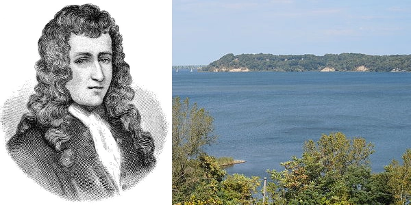
Image above: Cavelier de La Salle (left) and Irondequoit Bay (right), 2014, Daniel Penfield. Courtesy Wikipedia Commons. Below: Montage of First Nations camp in Ontario at Stony Lake (background), 1905, Edward Curtis. Courtesy Library of Congress. Inset (left) Ah-Wen-Eyu, Seneca Indian Woman, 1905, J.L. Blessing, and (right) Ki-On-Twog-Ky, known as Cornplanter, Seneca Chief, 1796, F. Bartoli. Courtesy Wikipedia Commons. Info source: "Exploration of the Great Lakes 1669-1670," 1879, Dollier de Casson and De Bre'hant de Galine'e, Ontario Historical Society; Library of Congress; Wikipedia.
History Photo Bomb
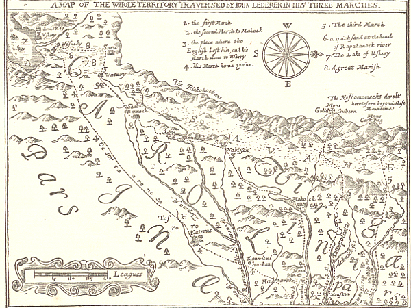
Map of the Lederer Expedition, the Discoveries of John Lederer, 1672. Courtesy Library of Congress, Hathitrust, Virginiaplaces.org.
Jacques Marquette and Louis Jolliet in a drawing of their canoe voyage of exploration in 1673, 1911, Edgar S. Cameron. Courtesy Library of Congress.
ABH Travel Tip
You can visit much of the Pre-Revolution history of the United States throughout the many trails and historic sites of the nation. And don't miss out on the Native American history throughout Florida or other regions. The history of the nation and North America comes from the culture of the many tribes that made up the mosaic of human culture in each state. They were here before the majority of us, after all, and their history is an amazing collection of wonder, beauty, and dedication to the land that sits beneath us.
Drawing depicting the capture of Mrs. Rolandson during the King Philip's War between colonists and New England tribes, 1857, Harper's Monthly. Courtesy Library of Congress.