Sponsor this page for $150 per year. Your banner or text ad can fill the space above.
Click here to Sponsor the page and how to reserve your ad.
-
Timeline
1682 Detail
April 9, 1682 - France claims the lower Mississippi River valley, Louisiana, when Robert Cavelier, Sieur de LaSalle explores the region.
Robert Cavelier, Sieur de LaSalle had been an explorer for many years before those explorations would take him that far south. He had explored the Great Lakes in 1669 looking for the Ohio River, i.e. a river west. He did not find that, but in 1670-71, he finally found the western tributaries of the Ohio River, although the river itself is credited as found by the English, Thomas Batts and Robert Fallam, in September 1671. LaSalle was not satisfied with his acccomplishments thus far, and obsessed with finding China. He built Fort Cataraqui, renamed Fort Frontenac after the Governor of New France, on July 12, 1673 on the Great Lakes at the site of Kingston with permission of the Iroquois nations, to ensure that France controlled the fur trade there.
Back in France in 1677, LaSalle embellished his accomplishments in New World exploration to the merchants and nobility and was given, on May 12, 1678, an exclusive right to explore the area between Florida and Mexico, and build forts where he thought necessary. With thirty inexperienced explorers, LaSalle returned to North America in September 1678. By December, he and Henry d'Tonti became the first Europeans to view Niagara Falls. The party built Fort Conti there, what we know as Fort Niagara, then commissioned the building of a ship, the Frontenac, lost on Lake Ontario, then a brigantine named Griffon. That ship set sail for Mackinac Island on August 7, 1679, anchoring there twenty days later. He would thence explore the area of Lake Michigan by canoes, build Fort Miami at St. Joseph, Michigan, and construct Fort Crévecoeur at Peoria, Illinois. Somewhere along the way, while transporting furs back to Niagara, the Griffon disappeared, never to be heard from again.
The 1682 Expedition
In January 1682, a party led by LaSalle left Fort Crévecoeur with thirty-three Frenchmen and eighteen Amerindians, sailing south along the Chicago, Fox, and Illinois Rivers until engaging the Mississippi River near Memphis in February. There he built Fort Prud'homme.
On April 6, 1682, LaSalle and party sighted the mouth of the Mississippi River, and at a spot near today's Venice, Louisiana, on April 9, he planted the flag of France and a tablet announcing that it was French territory, "In the name of Louis XIV, King of France and of Navarre, this nine of April, 1682."
In a red cloak, Robert Cavelier, de la Salle, announced, ... "I, René-Robert Cavelier de La Salle, by virtue of His Majesty's commission, which I hold in my hands, and which may be seen by all whom it may concern, have taken and do now take, in the name of His Majesty and of his successors to the crown, possession of the country of Louisiana, the seas, harbours, ports, bays, adjacent straits, and all the nations, peoples, provinces, cities, towns, villages, mines, minerals, fisheries, streams and rivers, with the extent of the said Louisiana."

Official Account from Joutel's Journal
"After La Salle had located, in his canoe, the nearby borders of the great sea, or gulf (of Mexico) which spread before them, the three parties reassembled (April 9th, 1682) at a spot where a column was erected and near it a plate was buried bearing the arms inscribed with the words of France, and "Louis Le Grande, Roy de France et de Navarre, Régne, Le Neuviéme, Avril, 1682." Then while the Te Deum, the Exaud@eacuteat and the Domine Salvum fac Regem were chanted, the volleys of musketry discharged by the men under arms, with cries of "Vive le Roi;" a cross was planted beside the column and Le Sieur de Salle, sword in hand, proclaimed the new-found territory as Louisiana, and Louis XIV as its King and rightful Lord.
The vast domain thus secured, after the manner of those times, to the French Crown, extended from the Alleghanies to the Rocky Mountains, and from the Rio Grande and the Gulf of Mexico to the farthest springs of the Missouri; but the name - Louisiana - which he gave it is now confined to a single commonwealth in the great sisterhood of states forming the United States of America.
Now, in the culmination of his triumph he was seized by an illness so severe as to threaten his life; and was unable to reach Fort Miami, even by slow stages, before August, and to rejoin Tonti, whom he had dispatched with news of his success to Canada. It seems to have been about this time that he began to abandon the difficult access which he had hitherto found, through Canada, with all its dangers and enemies, both whites and Indians; and to reach the region of his hopes and toils more directly by way of the Gulf of Mexico and the mouth of the Mississippi. His plans of descending that river by means of a vessel had twice been thwarted by disasters which proved its futility; and to attempt his purpose with canoes would be fraught with much difficulty and an enormous expense. He purposed now, in view of all his past experiences, to form on the banks of the Illinois a colony of French and Indians, as a place of storage of the furs which could be gathered by the various Western tribes; and as a defense against the Iroquois, who were alike inimical to the French and their Illinois allies. And rumors of an impending renewal of attack upon these allies urged him to greater speed; so he and Tonti repaired at once to "Starved Rock," before mentioned. This was a cliff, rising to a height of 125 feet, on the southern bank of the Illinois, presenting on three sides a sheer perpendicular wall, and on its other side a deep ravine; and it was accessible only by a difficult climb from behind. Its area was about an acre. This rock, in December, 1662, they cleared of the forest which crowned it, dragged timber up the ragged pathway, built storehouses and dwellings, and surrounded the summit with palisades. In this eyrie, which he christened Fort St. Louis of the Illinois, the winter was passed by La Salle's company, and by tactful management he secured the friendship of the neighboring tribes.
Around and under the protection of this fortification was soon gathered a motley gathering of the Illinois, and fragments of other tribes, all looking to him as their feudal lord; and to these followers, by virtue of his seigniorial rights, he began to grant parcels of land, and soon had the nucleus of a colony of some 20,000 souls, numbering about 4,000 warriors.
But, while thus engaged in the wilderness, matters in Canada were looming up adversely to his interests. His friend and patron, Count Frontenac, had been recalled to France, and the man who succeeded him as Governor-General, one de La Barre, was prejudiced against the explorer and constantly misrepresenting him to the home government in France. Furthermore, emboldened by the tone of the King's letter, who had been led to condemn La Salle's doings and plans, La Barre, with other associates, seized Fort Frontenac (which was La Salle's property), despite the remonstrances of the creditors and mortgagees; sold his stores for their own benefit, and turned his cattle to pasture on the growing crops. The position of La Salle became intolerable, cut off from his supplies, for which he entreated Governor La Barre in vain, threatened with an onslaught of the Iroquois, and unable to afford his own Indian allies the help which he had promised them, he had no other resource than to leave his wilderness colony in faithful Tonti's care, and cross the ocean again to face his enemies before the Court and King," Introduction in Joutel's Journal.
But de la Salle would not be deterred in defending his honor or planning a return trip to colonize the area he had found and defended. In 1664, Robert Cavelier de la Salle would return on his third voyage.
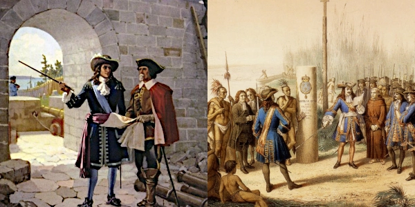
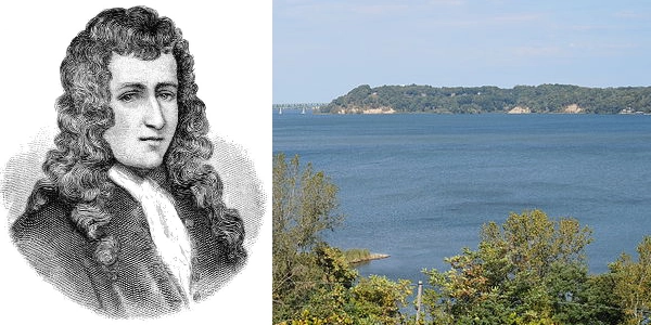
Image above: Montage (left) LaSalle at Fort Frontenac, 1652, John David Kelley. Courtesy Library and Archives Canada via Wikipedia, and (right), Painting of LaSalle taking possession of the lower Mississippi River for France, 1870's, lithograph by Jean-Adolphe Bocquin, printed by Lemercier & Cie, Paris. Courtesy Wikipedia Commons. Image below: Cavelier de La Salle (left) and Irondequoit Bay (right), 2014, Daniel Penfield. Courtesy Wikipedia Commons. Info source: Canadian Museum of History; "Joutel's Historical Journal of Monsieur de La Salle's last voyage to discover the river Mississippi," 1714, Henri Joutel; Wikipedia.
Back in France in 1677, LaSalle embellished his accomplishments in New World exploration to the merchants and nobility and was given, on May 12, 1678, an exclusive right to explore the area between Florida and Mexico, and build forts where he thought necessary. With thirty inexperienced explorers, LaSalle returned to North America in September 1678. By December, he and Henry d'Tonti became the first Europeans to view Niagara Falls. The party built Fort Conti there, what we know as Fort Niagara, then commissioned the building of a ship, the Frontenac, lost on Lake Ontario, then a brigantine named Griffon. That ship set sail for Mackinac Island on August 7, 1679, anchoring there twenty days later. He would thence explore the area of Lake Michigan by canoes, build Fort Miami at St. Joseph, Michigan, and construct Fort Crévecoeur at Peoria, Illinois. Somewhere along the way, while transporting furs back to Niagara, the Griffon disappeared, never to be heard from again.
On April 6, 1682, LaSalle and party sighted the mouth of the Mississippi River, and at a spot near today's Venice, Louisiana, on April 9, he planted the flag of France and a tablet announcing that it was French territory, "In the name of Louis XIV, King of France and of Navarre, this nine of April, 1682."
In a red cloak, Robert Cavelier, de la Salle, announced, ... "I, René-Robert Cavelier de La Salle, by virtue of His Majesty's commission, which I hold in my hands, and which may be seen by all whom it may concern, have taken and do now take, in the name of His Majesty and of his successors to the crown, possession of the country of Louisiana, the seas, harbours, ports, bays, adjacent straits, and all the nations, peoples, provinces, cities, towns, villages, mines, minerals, fisheries, streams and rivers, with the extent of the said Louisiana."
The vast domain thus secured, after the manner of those times, to the French Crown, extended from the Alleghanies to the Rocky Mountains, and from the Rio Grande and the Gulf of Mexico to the farthest springs of the Missouri; but the name - Louisiana - which he gave it is now confined to a single commonwealth in the great sisterhood of states forming the United States of America.
Now, in the culmination of his triumph he was seized by an illness so severe as to threaten his life; and was unable to reach Fort Miami, even by slow stages, before August, and to rejoin Tonti, whom he had dispatched with news of his success to Canada. It seems to have been about this time that he began to abandon the difficult access which he had hitherto found, through Canada, with all its dangers and enemies, both whites and Indians; and to reach the region of his hopes and toils more directly by way of the Gulf of Mexico and the mouth of the Mississippi. His plans of descending that river by means of a vessel had twice been thwarted by disasters which proved its futility; and to attempt his purpose with canoes would be fraught with much difficulty and an enormous expense. He purposed now, in view of all his past experiences, to form on the banks of the Illinois a colony of French and Indians, as a place of storage of the furs which could be gathered by the various Western tribes; and as a defense against the Iroquois, who were alike inimical to the French and their Illinois allies. And rumors of an impending renewal of attack upon these allies urged him to greater speed; so he and Tonti repaired at once to "Starved Rock," before mentioned. This was a cliff, rising to a height of 125 feet, on the southern bank of the Illinois, presenting on three sides a sheer perpendicular wall, and on its other side a deep ravine; and it was accessible only by a difficult climb from behind. Its area was about an acre. This rock, in December, 1662, they cleared of the forest which crowned it, dragged timber up the ragged pathway, built storehouses and dwellings, and surrounded the summit with palisades. In this eyrie, which he christened Fort St. Louis of the Illinois, the winter was passed by La Salle's company, and by tactful management he secured the friendship of the neighboring tribes.
Around and under the protection of this fortification was soon gathered a motley gathering of the Illinois, and fragments of other tribes, all looking to him as their feudal lord; and to these followers, by virtue of his seigniorial rights, he began to grant parcels of land, and soon had the nucleus of a colony of some 20,000 souls, numbering about 4,000 warriors.
But, while thus engaged in the wilderness, matters in Canada were looming up adversely to his interests. His friend and patron, Count Frontenac, had been recalled to France, and the man who succeeded him as Governor-General, one de La Barre, was prejudiced against the explorer and constantly misrepresenting him to the home government in France. Furthermore, emboldened by the tone of the King's letter, who had been led to condemn La Salle's doings and plans, La Barre, with other associates, seized Fort Frontenac (which was La Salle's property), despite the remonstrances of the creditors and mortgagees; sold his stores for their own benefit, and turned his cattle to pasture on the growing crops. The position of La Salle became intolerable, cut off from his supplies, for which he entreated Governor La Barre in vain, threatened with an onslaught of the Iroquois, and unable to afford his own Indian allies the help which he had promised them, he had no other resource than to leave his wilderness colony in faithful Tonti's care, and cross the ocean again to face his enemies before the Court and King," Introduction in Joutel's Journal.
But de la Salle would not be deterred in defending his honor or planning a return trip to colonize the area he had found and defended. In 1664, Robert Cavelier de la Salle would return on his third voyage.
Image above: Montage (left) LaSalle at Fort Frontenac, 1652, John David Kelley. Courtesy Library and Archives Canada via Wikipedia, and (right), Painting of LaSalle taking possession of the lower Mississippi River for France, 1870's, lithograph by Jean-Adolphe Bocquin, printed by Lemercier & Cie, Paris. Courtesy Wikipedia Commons. Image below: Cavelier de La Salle (left) and Irondequoit Bay (right), 2014, Daniel Penfield. Courtesy Wikipedia Commons. Info source: Canadian Museum of History; "Joutel's Historical Journal of Monsieur de La Salle's last voyage to discover the river Mississippi," 1714, Henri Joutel; Wikipedia.
History Photo Bomb

The Treaty of Penn with the Indians, 1771-2, Benjamin West. Courtesy Pennsylvania Academy of Fine Arts via Wikipedia Commons.


Painting titled Portrait of a Man, supposedly of Joseph Dudley, circa late 17th century. Courtesy Wikipedica Commons.
ABH Travel Tip
You can visit much of the Pre-Revolution history of the United States throughout the many trails and historic sites of the nation. And don't miss out on the Native American history throughout Florida or other regions. The history of the nation and North America comes from the culture of the many tribes that made up the mosaic of human culture in each state. They were here before the majority of us, after all, and their history is an amazing collection of wonder, beauty, and dedication to the land that sits beneath us.

Painting of the Signing of the Mayflower Compact, 1899, Jean Leon Gerome Ferris. Courtesy Wikipedia Commons.
Timeline Book
